Look at Jordan on a map and you might not think “tourist destination.” Bordered by Syria to the north, Iraq to the east, Israel and Palestine to the west, Jordan is the calm eye in the center of the Middle East storm. And its capital city of Amman is full of surprises.
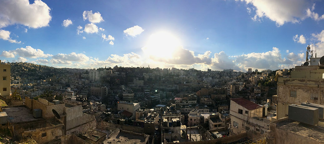
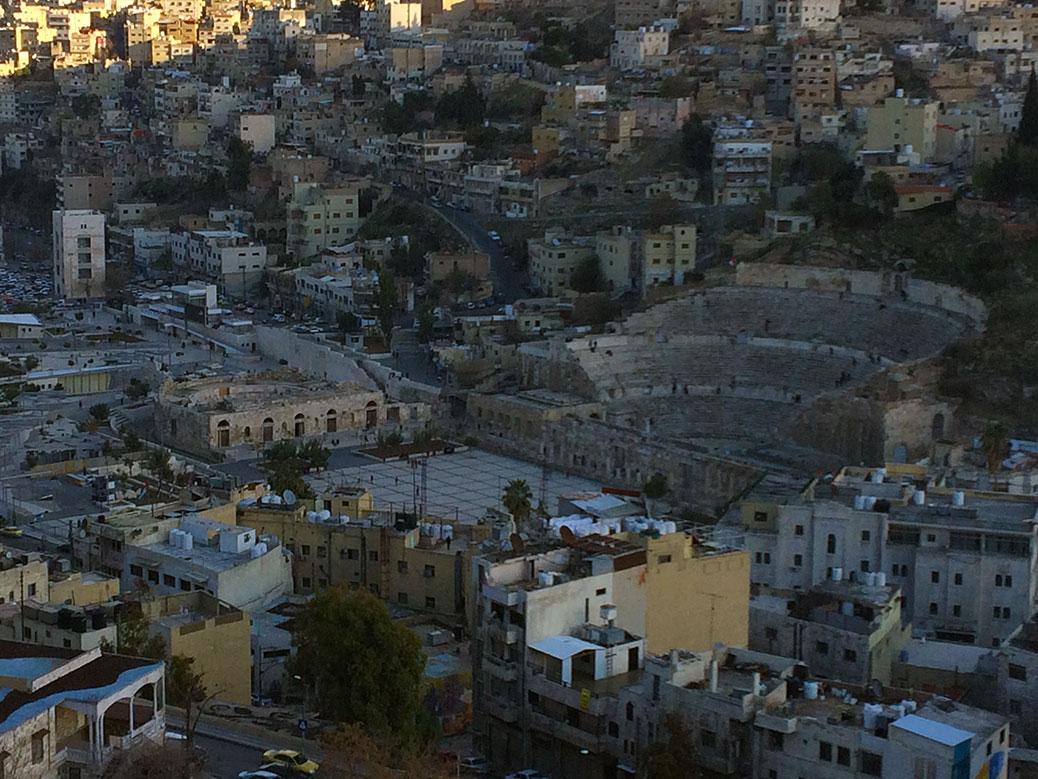
View of Amman from the Amman Citadel.
Amman is one of the Arab world’s most westernized countries, taking influences from each of its various conquerers. The first evidence of civilization dates back to 7600 B.C. and the settlement of Ain Ghazal. In the 3rd century B.C., the Greeks renamed the city Philadelphia. The Roman Empire arrived a couple hundred years later, leaving remnants behind that stand as tourist sites today. In the 7th century A.D., the Rashidun Caliphate introduced Islam. The Ammonites gave the city its modern name in the 13th century. The Ottomans followed in the 16th century and spent the next 400 years laying the foundation for modern Jordan.
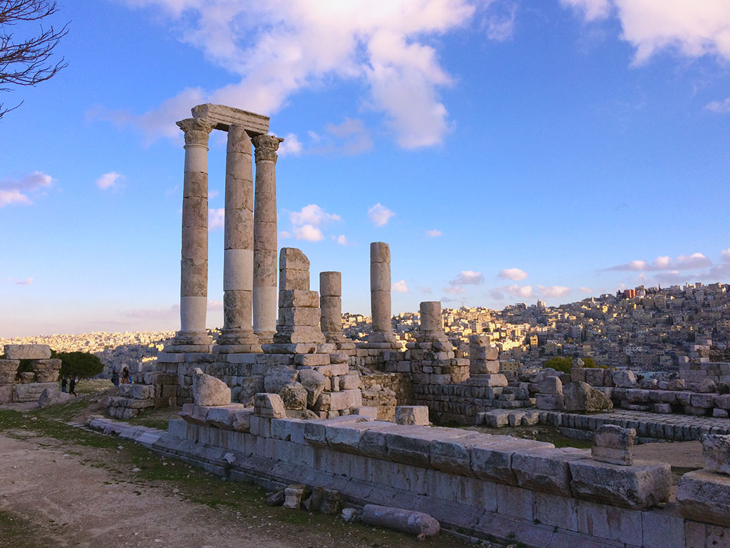
The Temple of Hercules is one of Amman’s many remnants of the Roman Empire.
Jordan and Amman surprised us, starting with Queen Alia International Airport, located about 20 miles south of central Amman. The clean, modern airport with short lines and polite customs agents was a welcome departure from the chaos of Cairo International Airport. Our driver waited patiently near the entrance with our name on a card to take us to the city center. A Muslim man performed ritual foot washing in the men’s restroom sink.
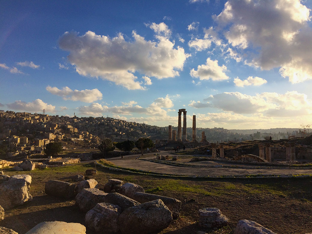
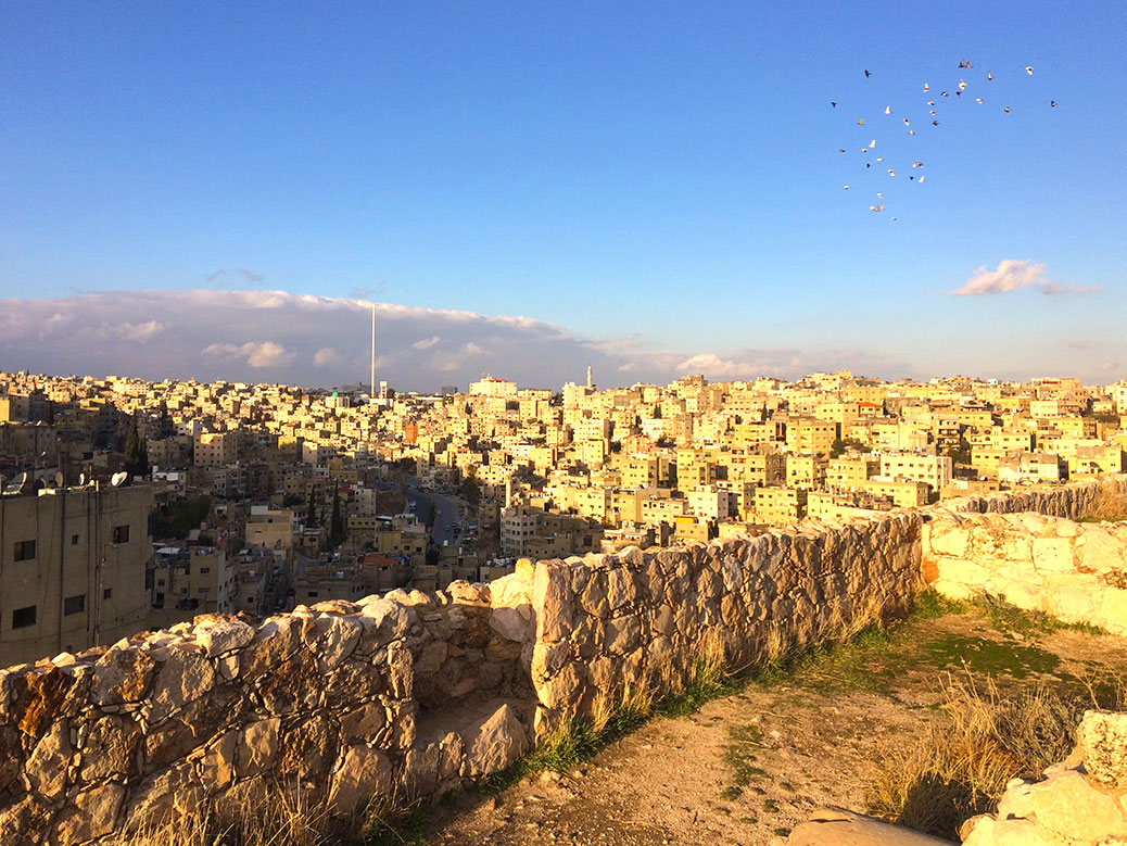
By late afternoon, we’d arrived in the lively city center and immediately set out for sightseeing before sunset. Amman is built into 19 hills, which offer several unique and breathtaking views of the city. Atop one of those hills is Amman Citadel where the aforementioned history of Amman is on full display.
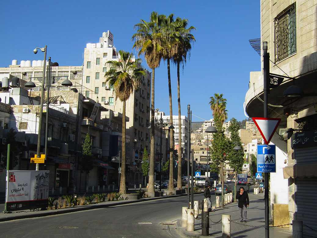
King Faisal Street is the commercial center of Amman. While crowded and noisy during the day and early evening, only a handful of pedestrians were out and about in the early morning.
From the commercial center of King Faisal Street, the road to the Citadel is a series of switchbacks up the side of a hill. On foot, we found ourselves winding between homes, accidentally ending up on someone’s back porch along the way. Struggling to find the entrance, a local suggested we climb a short stone wall and go up the side of the hill. After a couple attempts that resulted in a full blowout of an old pair of pants, we thanked him for his advice and found an alternate path to the top.
Amman’s Temple of Hercules at sunset.
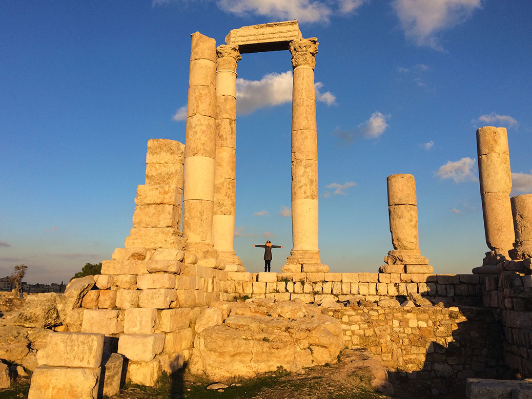
Once inside, we were met by only a handful of tourists wandering the grounds. The jewel of the Citadel is the Temple of Hercules. Visible from various points in the city, the 33-foot tall Roman columns glowed gold in the afternoon sun. Built around 160 A.D., it’s believed that the final structure would have resembled the Pantheon in Rome. Today it has more in common with the ruins of the Temple of Saturn in the Roman Forum.
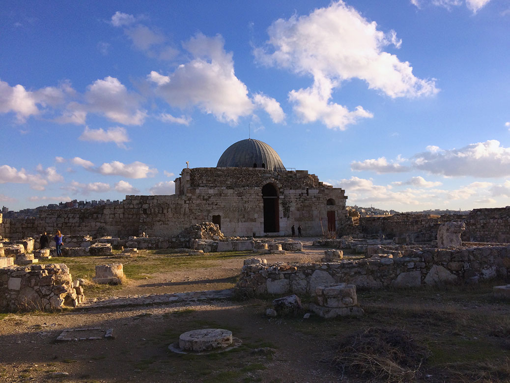
Built around 730 A.D., Umayyad Palace in the Amman Citadel was likely a home and office for the governor of Amman. An earthquake in 749 destroyed much of the palace. The dome was only recently restored.
Near the back of the Citadel grounds we found the restored remains of Umayyad Palace. The Byzantine-style residence would have been the home and workplace of the governor of Amman. Despite falling victim to a strong earthquake in 749, the palace continued to be inhabited well into the 12th century, although it was never fully restored.
A view of Amman from the Amman Citadel.
As one of the highest points in the city, the views at sunset were stunning. Flocks of black and white birds darted across the sky in swarms. The bustle of the city during rush hour dulled to a quiet hum.
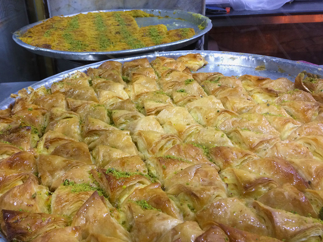
Turning out cheap eats for more than half a century, Hashem Restaurant is a must-stop while in Amman.
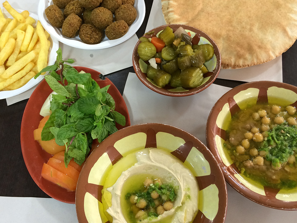
We made our way back down to the city center, ready for dinner. When we travel, we favor local places with local cuisine and Hashem was exactly what we needed.
From the street, the 50-plus-year-old family-owned restaurant appears to be a few tables, in an alleyway. On our first visit, we took one of the tables near the sidewalk near a group of tourists, but on our second visit (yes, we went twice), we continued down the alley and through the kitchen to a larger dining area filled with locals.
Here the spirit of Hashem truly shined. The waiters hustled with trays full of food and water glasses, their feet slipping on the tile floor, but never spilling a drop. The food is vegetarian. There is no menu and no ordering unless you want mint tea… which you do.
The waiter brings out a plate of raw onion, tomatoes and mint along with a large piece of flat bread. Soon, a plate of falafel, french fries, seasoned fava beans (ful medames) and hummus mixed with yogurt arrive at the table. The falafel is considered the best in Amman and I’m not going to argue.
Opened in 1951, you’ll recognize the small Kunafa shop known as by Habibah by the not-so-small lines.
After dinner, we saw a line. If we’ve learned anything in our travels, it’s “if you see a line, get in it.” This particular line led to the tiny pastry shop Habibah. Opened in 1951 in an alleyway next to a bank, the shop cranks out plate after plate of kunafa. The queue leads to a small booth outside where we placed our order with the cashier—”one of each, please,” not entirely sure what we were getting.
From there, we took our receipt into the narrow shop with just enough room for two people to squeeze past each other. The kunafa—a mild white cheese melted under shredded wheat and covered in sugar syrup—was chopped, flipped on a paper plate and slid across the counter toward us. We shimmied past the queue and joined the others outside to enjoy our warm, sweet-and-savory dessert.
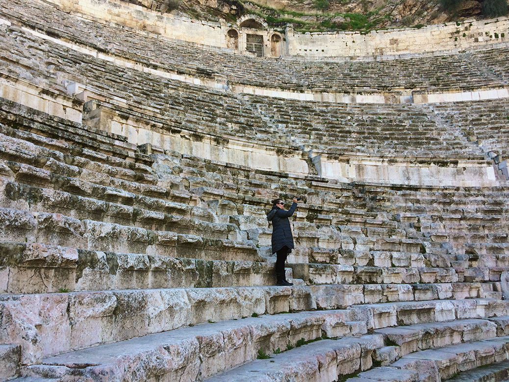
Dating to the 2nd century, the Roman Theater in the heart of Amman still serves as a cultural center today.
Inside the 6,000 seat Roman Theater in Amman.
The following morning before we departed for Petra(check out our post on the Seven Wonders of the World), we grabbed a cup of Turkish coffee and walked over to the Roman Theater. The 6,000-seat theater was built during the 2nd century reign of Roman emperor Antoninus Pius. It still serves as Amman’s living room, hosting concerts and community events on a regular basis.
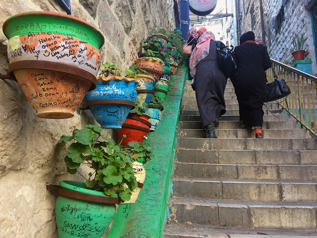
A staircase off Prince Muhammad Street features colorful flowerpots with graffiti left by visitors from around the world.
We returned to Amman after our Petra tour with a few hours to pass before leaving for the airport. After lunch at Hashem and another stop at Habibah, we wandered the streets, popping into the occasional shop and enjoying our last hours in Amman.
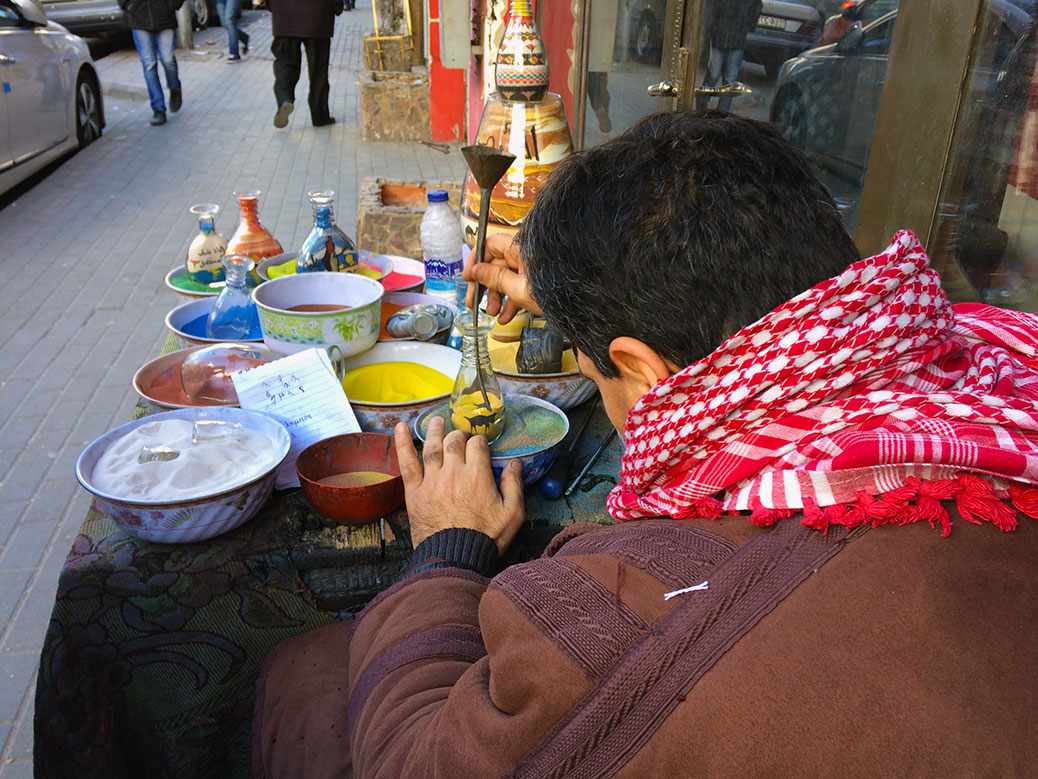
A sand artist shows off his skills on an Amman side street.
A man with a table full of colored sand set up shop along the sidewalk. He motioned us over, picked up an empty glass jar and dumped some yellow sand in the bottom. He picked up a metal funnel and began to pour various colored sand into the jar. The funnel went up, the funnel went down. A black streak suddenly became the silhouette of a camel. Blue sand became a desert oasis. Orange sand turned into a sunset. All the while, he spun the jar around, creating mirror images on each side.
As he finished he paused momentarily, at which point I expected the sales pitch. Instead, he picked up another jar and began again. He thanked us for our time, we returned the thanks and continued our journey. It was the perfect end to our time in Jordan; a reflection of the hospitality and low-key vibe we experienced during our stay.
If You Go
Art Hotel 32 King Faisal Street — Simple, clean hotel in the heart of downtown Amman. Buffet breakfast included. The staff is wonderful and the manager, Sameer, helped us with car transfers both before our stay and when we had trouble getting back to the airport days after we’d checked out.
Hashem Restaurant
Al-Malek Faisal Street — The best falafel in Jordan. Head toward the back to dine with the locals and try the mint tea.
Habibah Sweets Al Hazar Street 2 — You can find a few Habibah locations, but this is the original. Ask for one of each of whatever kunafa they happen to be serving.
After 26 hours of travel from Portland through Vancouver B.C. and London, I finally arrived in Cairo late on Christmas night, excited to see Viktoria after four months apart. My time on the ground was short-lived. We woke up the next day and headed back to the airport to embark on a Nile River Cruise of the temples of Upper Egypt.
Day 1: Aswan Dam and the Temples of Philae
Our Memphis Tours group had already started the day’s activities by the time we arrived in Aswan. We missed the unfinished obelisk—a 3,500 year old partially carved tower that would have been the largest in ancient Egypt had it been completed. We soon joined the rest of our tour group and set out for Aswan Dam.
The Temples of Philae were relocated from Philae Island to Agilika Island after the construction of Aswan Dam threatened to wash away the 2,300 year old complex.
The Low Dam was completed by the British in 1902, while the High Dam was financed by the Soviet Union and completed in 1970. The latter drastically changed the landscape of Egypt, regulating the alternating cycles of drought and flooding. After the completion of the Low Dam, several archeological sites were regularly flooded and in danger of becoming lost to the Nile.
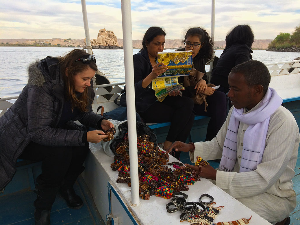
On our way to Agilika Island, the ferry boat captain brought out bracelets and other trinkets for sale.
The Temples of Philae were among those sites. In the 1960s, UNESCO led a project to move the temples to higher ground on Agilkia Island. We boarded a boat to the island just before sunset. Our boat captain doubled as a souvenir vendor, spreading a bag full of bracelets on an empty bench as we drifted toward the island.
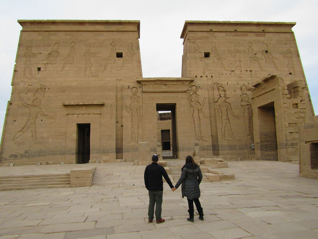
Together again in front of the First Pylon of the Temples of Philae in Aswan.
The temple complex provided an impressive start to the trip. The architecture of the temples of Upper Egypt is surprising compared to the pyramids of Lower Egypt. Towers with intimidating carvings surround massive doorways. At Philae, a relief of first-century B.C. king Ptolemy XII Auletes clubbing an enemy is prominent, our guide using various members of the group as props to demonstrate the meaning of the carvings. It would be the first of several times I would be recruited to play the role of a Syrian enemy—it’s the beard.
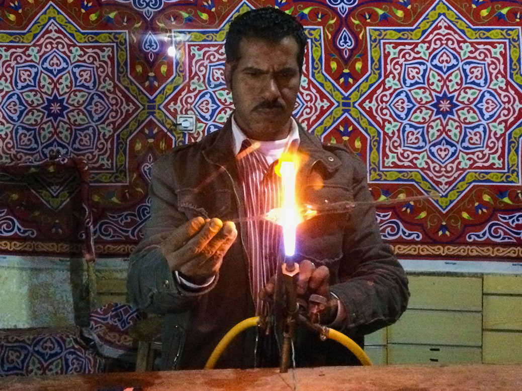
Outside the Alfayed Perfume Co. in Aswan, perfume bottles are made by hand to be used in the store.
Before returning to the boat, we stopped at the Alfayed Perfume Company. Outside, a man made glass perfume bottles in real time. Inside, a choreographed sales pitch walked us through the scents and medicinal uses of various essential oils.
The shop staff offered a free massage to show off some of the oils. Through the silence of the rest of our group, we volunteered to seize the day. Viktoria was led to a seating area off to the side, while I was just ushered behind our group and asked to remove my shirt in the middle of the showroom. I paused at the awkwardness of the situation, but ultimately succumbed to the request. After the long flight, it was well worth it.
Day 2: Kom Ombo and Edfu
The phone rang at 5:45 a.m. to let us know day 2 had begun. Overnight we’d sailed 40 miles to the north, arriving outside the entrance of Kom Ombo temple. The early wake-up call allowed us to see the temple in the stunning morning light.
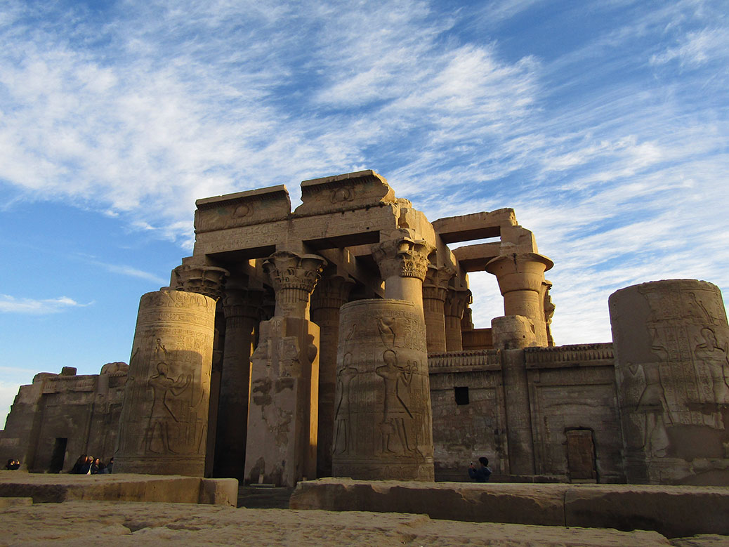
Aswan’s Temple of Kom Ombo.
The unique temple shows off the construction techniques of ancient craftsmen. A rare “double temple,” Kom Ombo honors two gods and each side is a mirror of the other down the temple’s center axis. Levels placed on 2,000-year-old sandstone blocks show a perfect 0º plane.
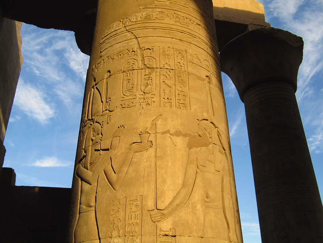
Carvings in a column at the Temple of Kom Ombo in Aswan.
The temple’s southern structure is dedicated to the god Sobek, often depicted as a human with a crocodile head. During excavation, more than 300 mummified crocodiles were found in the area. Several are on display at the nearby Crocodile Museum.
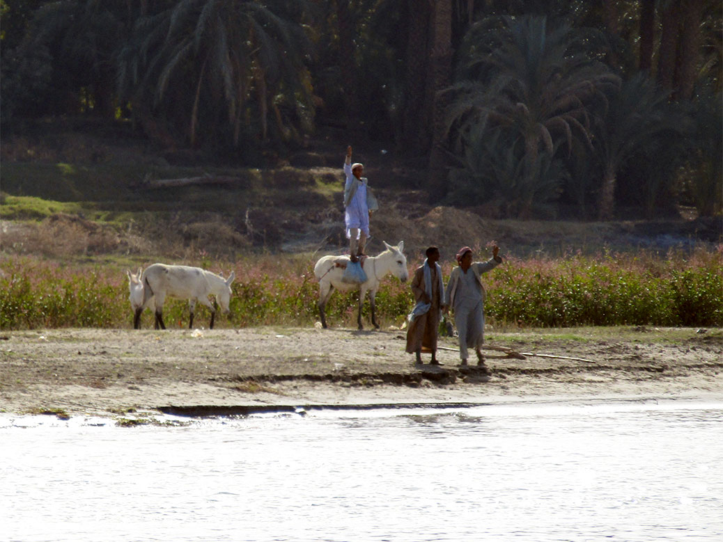
Daily life along the Nile River. The man flat-foot jumped atop his donkey to wave at our boat.
We ran the gauntlet of vendors along the river back to the boat for lunch while we sailed north to Edfu. It gave us an opportunity to watch the world as it exists on the banks of the Nile. Farmers worked the fertile and surprisingly green strip of land along the river. At one point, a man jumped atop his donkey to wave at the boat, excited by our returned greetings.
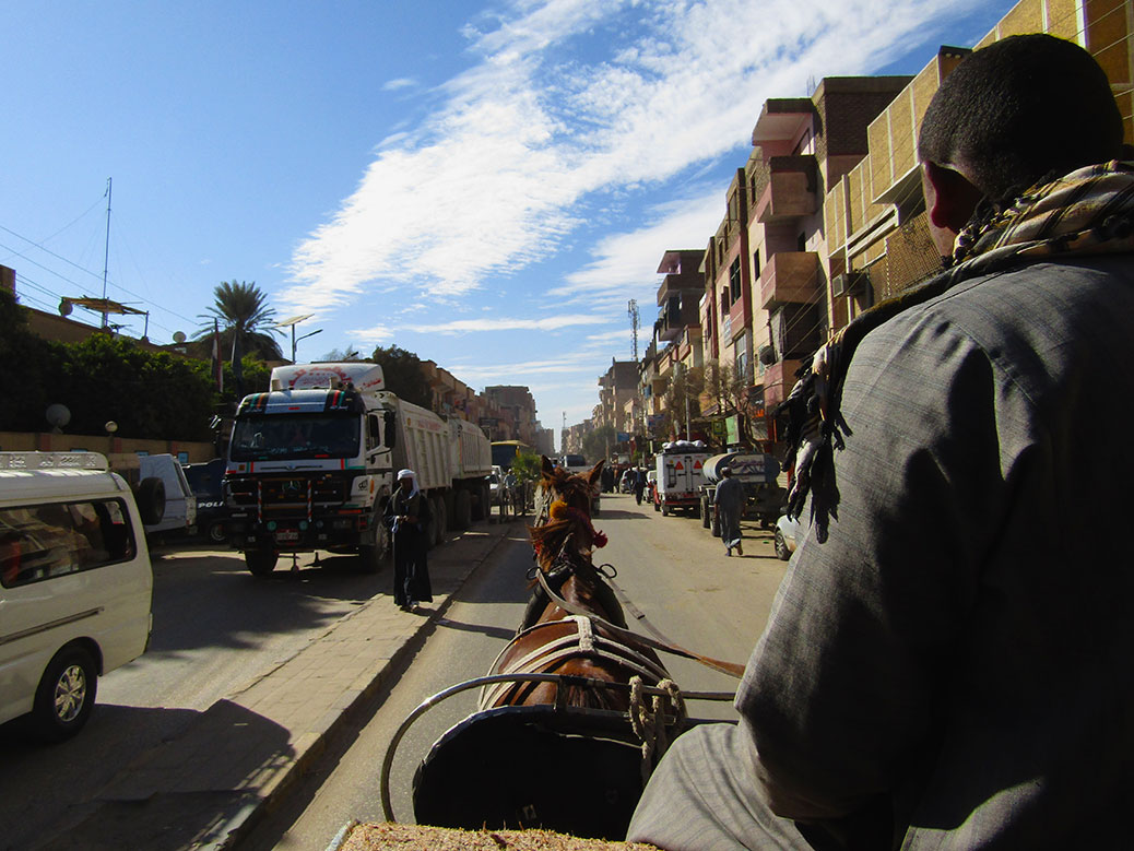
We were taken to Edfu Temple by horse-drawn carriage.
After a couple hours, we arrived on the banks of Edfu. Our guide assigned us a horse-drawn cart and we quickly set off for the Temple of Edfu. Cars and carts co-existed on the dusty city streets. Along the route, a vendor hopped into the empty seat next to our driver. He would quickly learn our names and kept an eye on us during the entirety of our temple visit with hopes we’d visit his souvenir shop. A small shouting match broke out when another vendor approached us—we’d clearly already been claimed.
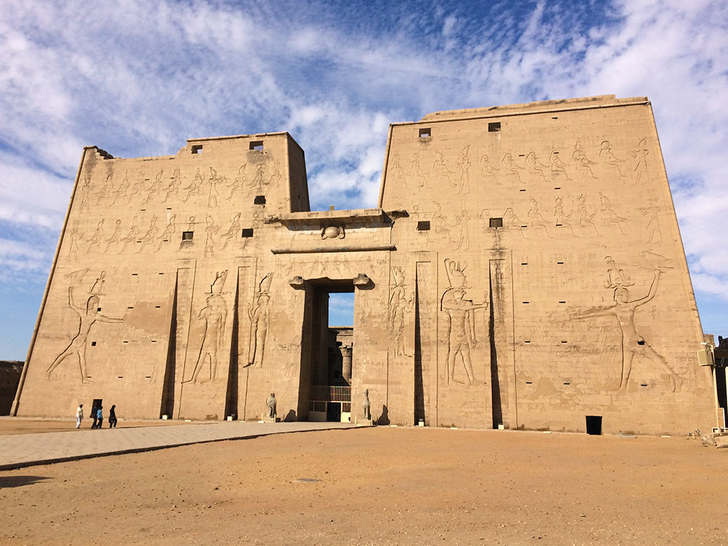
The first pylon of the Temple of Edfu.
Similar in appearance to the temples at Philae and Kom Ombo, the Temple of Edfu is one of the best preserved examples of its style. Construction began around 237 B.C. and was an active site until 391 A.D. when the Roman Empire banned non-Christian religious worship. Silt from the Nile and wind-blown desert sand eventually buried the temple, providing a natural protective casing.
For centuries, the Temple of Edfu was buried under sand and silt from the Nile River. As a result, it’s one of the best preserved temples in Upper Egypt. Carvings and original coloring can still be seen throughout the complex.
In the 1890s, French archeologists began clearing Edfu from its cocoon. Large carvings and reliefs appear as they would have 2,000 years ago, many with original color still intact. One of the more impressive carvings serves as a medical textbook, showing various tools and techniques used in ancient surgery.
With Horus and our Memphis Tours group at Edfu Temple.
The statue of the falcon god Horus is Edfu’s biggest draw. Perched outside the entrance to the Hypostyle Hall, the perfectly-preserved statue features Horus in bird form, wearing the double crown of Upper and Lower Egypt. Our group waited patiently with the throngs of selfie-takers to get a souvenir photo.
We navigated through the vendors, kindly declining the aforementioned shopkeeper’s insistence that we take a look, and returned to the boat. Still reeling from jetlag and the early wake-up call, we headed back to our cabin for a pre-dinner nap.
The after-dusk silence was soon shattered by a man in a rowboat who pulled alongside our boat. “Hallo!!! Good evening!” he repeated, over and over and over… There would be no rest for the weary. We headed below deck for the nightly buffet-style dinner before finally passing out for good.
Day 3: Valley of the Kings
The only thing worse than the expected wake-up call is an unexpected one. Looking forward to sleeping in a little, we were shocked awake by the phone. Our guide, Mohammad, was calling to inform us that we were leaving in 10 minutes. We soon learned that the posted schedule we checked the night before was for another group.
We quickly got ready, grabbed a couple rolls from the dining room and walked out to the dock. Overnight, we’d arrived in Luxor, the ancient city of Thebes and the former capital of Upper Egypt. We boarded a ferry boat to cross to the West Bank where a bus awaited.
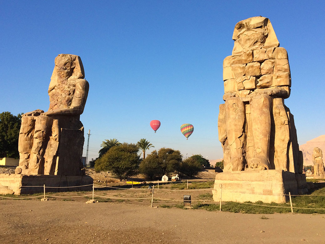
The twin statues of Pharaoh Amenhotep III known as the Colossi of Memnon in Luxor.
After a short drive, we arrived at the twin, 60-feet tall Colossi of Memnon statues. Modeled after Pharaoh Amenhotep III, ruler of Egypt from 1386 to 1349 B.C., the 720-ton sandstone statues look to the east, back toward the Nile River. 3,400 years of exposure to the elements have taken their toll as the details are mostly indistinguishable.
The Colossi have been a tourist destination for more than 2,000 years. Visitors spiked following a 27 B.C. earthquake that collapsed the upper half of the northern statue. In the early mornings that followed, the remaining lower-half of the statue was reported to “sing.” Hearing the song of the “Vocal Memnon” was considered lucky, luring poets, historians, politicians and even Roman emperors. Around 199 A.D., the Romans rebuilt the upper portion of the statue, putting an end to the song of Memnon.
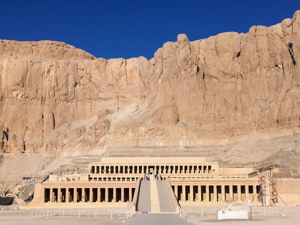
The Mortuary Temple of Hatshepsut near Luxor’s Valley of the Kings.
We continued up the highway to the Mortuary Temple of Hatshepsut. A unique blend of Egyptian and Greek Classical architecture, the temple serves as a memorial to Pharaoh Hatshepsut, Egypt’s second female pharaoh.
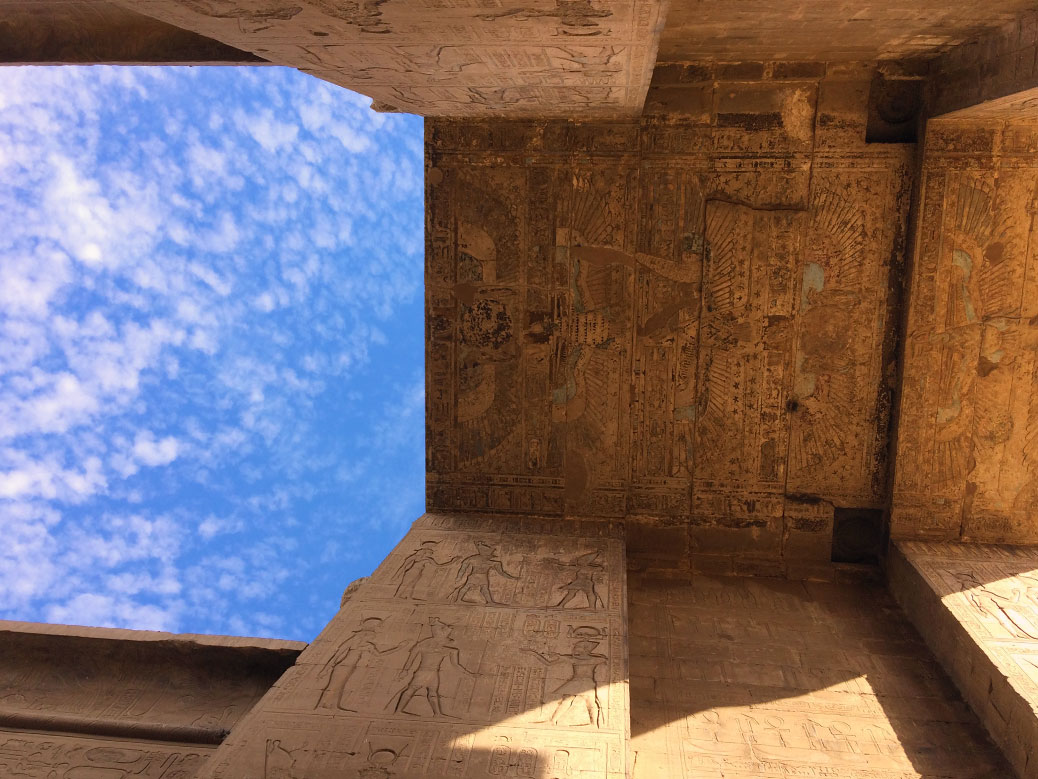
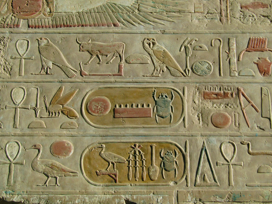
Enclosed hieroglyphics in the Temple of Hatshepsut. Known as cartouche, they indicate a name and the beetle (scarab) usually denotes the name of a pharaoh. The top shows the name of Pharaoh Thutmose III, nephew/stepson and heir to Hatshepsut.
Significant restoration work by Polish teams has restored the temple to near-original condition. Hieroglyphics clearly tell the story of Hatshepsut’s birth and rise to power. Her reign from 1478–1458 B.C. is considered one of the most successful in Egyptian history. She established trade with modern-day Ethiopia and Sudan and commissioned hundreds of construction projects, including the unfinished obelisk in Aswan and many structures in the Temple of Karnak.
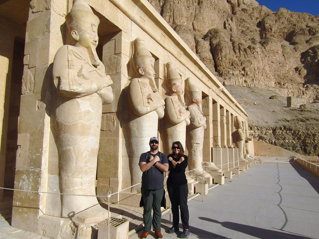
Standing with the statues outside of Hatshepsut Temple.
As with most sites, Hatshepsut’s temple is crawling with vendors and “guides” looking to make easy money. One man swapped his turban for my Chicago Cubs cap, then posed with me for a “crossed arms” photo reflective of the statues outside the temple’s main hall. Even after I slipped him a couple pounds, he continued to show us places for unique photos and pointed out hidden carvings.
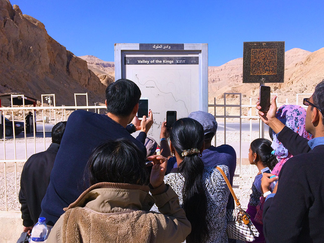
No photos allowed inside the Valley of the Kings, but this map outside the gates was fair game.
After a short coffee break, we boarded the bus and continued up the road to the celebrated Valley of the Kings. From 1539-1075 B.C., more than 60 Egyptian pharaohs and nobles were enshrined in sandstone tombs dug deep into the base of al-Qurn, the highest peak of the Theban Hills.
We started in the tomb of Ramesses IV. The second tomb discovered in the valley, it’s notable for graffiti from tourists who have visited over several centuries. More than 650 drawings and inscriptions from ancient Greek and Roman visitors have been found as well as 50-plus examples left by Coptic monks who once lived in the tombs.
We also visited the tombs of Ramesses IX and Merneptah, but the clear highlight is the tomb known simply as KV62—the final resting place of Tutankhamun. The source of much of the mystery around ancient Egypt, the tomb was hidden under a workers village and left undiscovered until 1922. Inside, the completely intact tomb contained 5,398 items Tut would need in the afterlife.
Today all of the artifacts are in various museums, including the golden funerary mask. Considered one of the world’s great works of art, the mask can currently be seen in Cairo’s Museum of Egyptian Antiquities along with several other items from the tomb.
However, the most important artifact—Tut himself—is still in the tomb. Preserved in a climate-controlled glass case, you can see Egypt’s most famous pharaoh up close and personal. Due to concerns about preservation, Tut’s tomb will eventually be closed to visitors. However, a perfect replica is currently under construction nearby that will allow visitors to touch and observe the tomb in detail previously unavailable to the public.
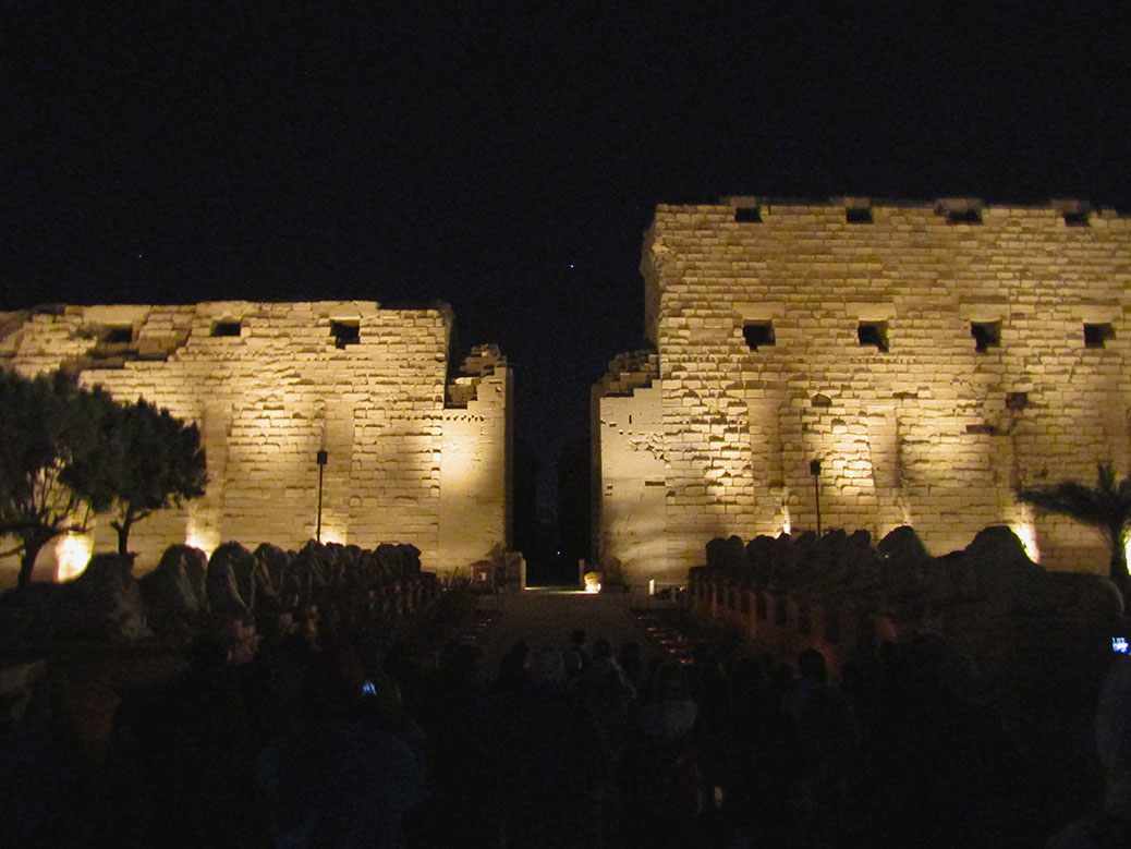
Luxor’s Karnak Temple at night during the Sound and Light Show.
That evening, we joined a side excursion to Karnak Temple for the Sound and Light show. Many of ancient Egypt’s most popular sights have added projection and audio systems as a way of extending opportunities for tourist dollars. The walking tour tells the story of the temple in dramatic detail.
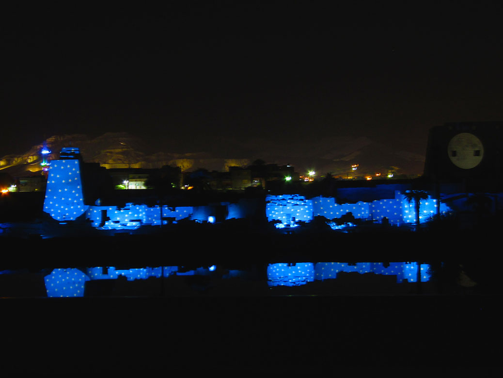
The Sound and Light Show at Karnak Temple reflects on the Sacred Lake.
After passing through the various pylons and Hypostyle Hall, we arrived at a set of bleachers near the Sacred Lake. The story of Karnak and the city of Thebes is projected onto the monument opposite the lake, the light reflecting on the water’s surface. While obviously designed as a tourist experience, it’s a unique way to visit the sprawling, ancient site.
Day 4: Karnak Temple Complex
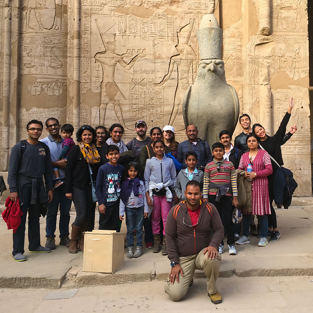
The last day of our Nile River cruise finally offered an opportunity for a slow start to the day. The various tour groups began to disband as we enjoyed a leisurely breakfast. We joined the Mutha family—two doctors and their children from India—for some final sightseeing.
Karnak Temple during the daytime.
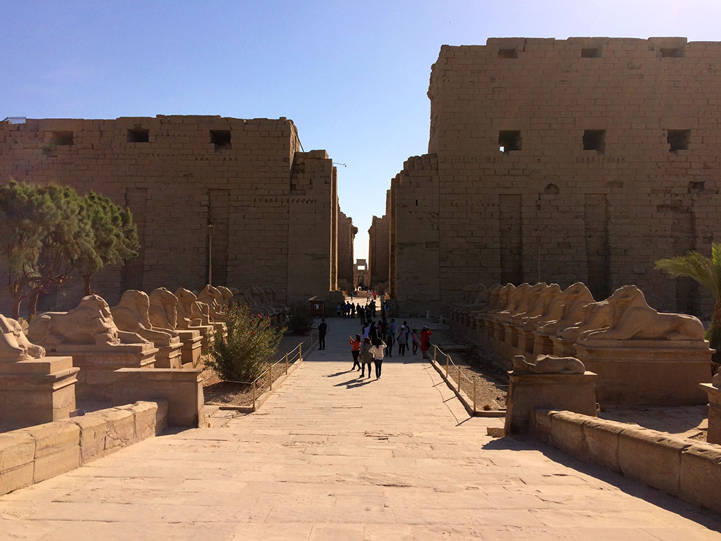
Karnak Temple during the daytime allows the morning sun to highlight the colors and architecture of ancient Thebes. The second-largest religious site in the world after Cambodia’s Angkor Wat complex was a fitting final-day destination. While the architecture itself wasn’t unique to anything we’d seen before, the size and scale is one-of-a-kind.
From the 134 columns of the 50,000 sq. ft. Hypostyle Hall to the 70-ton beams balanced atop the columns, Karnak is a marvel of ancient construction. Built under the watch of 30 pharaohs over hundreds of years, it’s a monument to both the rise and fall of ancient Egypt. As a result, Karnak is the most visited tourist site in Egypt after the Pyramids of Giza.
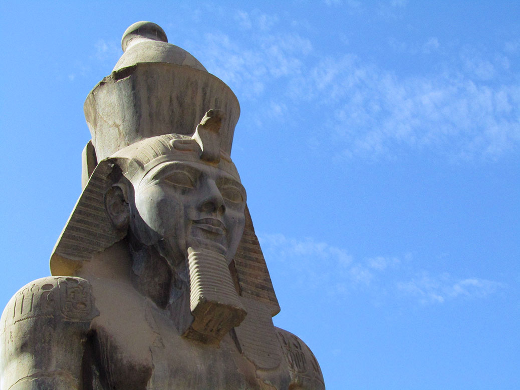
Statue of Ramses II in Luxor Temple.
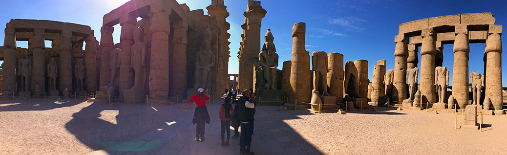
We finished our tour at Luxor Temple, believed to be the coronation site of the kings of ancient Egypt. Architecturally, Luxor follows the same model as the other temples of Upper Egypt, but with a few unique surprises. At the temple’s entrance, two giant statues of Rameses II guard the doorway.
A panoramic view of Luxor Temple.
Further inside, typical hieroglyphics and relief carvings decorate the walls. But hidden away atop a wall in a shadowy corner, a different decoration is barely visible. A Roman fresco-style painting can still be seen from the era when Luxor Temple was used as a fortress for the invading Roman Empire.
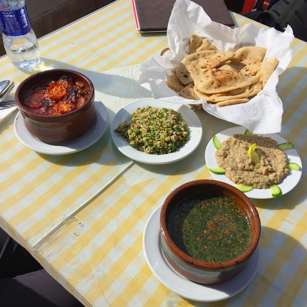
Potato and okra tagine, tabbouleh, baladi bread, baba ganoush and molokhia at Abu Gad.
After a few days of “cruise food,” the opportunity to try some of the local cuisine called our names. We turned down our tour guide’s recommendation of McDonald’s, instead opting for Abu Gad. Climbing the stairs of the multi-story restaurant to the rooftop dining room, we could hear the hustle and bustle of modern-day Luxor. We sampled several specialties, including an okra-like soup called molokhia and a potato and okra tagine cooked in the traditional clay pot.
If You Go
Memphis Tours Steigenberger Minerva Nile Cruise
Four-day Nile River cruise from Aswan to Luxor visiting the Philae Temple, Edfu, Valley of the Kings, Luxor and more. Meals included on board.
Abu Gad Restaurant
Typical Egyptian meals, sandwiches, pasta and more. Luxor City near Luxor Temple.
Westerners have a long tradition of discovering things that were never lost in the first place. The ancient city of Petra, hidden away in Jordan’s southwestern desert, was “discovered” by Swiss explorer Johann Ludwig Burckhardt in 1812. However, the Rose City—named for the color of the sandstone in late afternoon—had long been an object of curiosity in the region.
Today, Petra is one of the New Seven Wonders of the World (check out our rundown of the Seven Wonders we’ve visited) and Jordan’s most popular tourist destination. But 2,000 years ago, it was the capital city for the nomadic Nabataean people. They lived in caves chiseled deep into the sandstone and carved intricate facades into the outer walls to indicate temples and tombs.
After driving from Amman the night before, we started our visit early to beat the rush of tourists. Upon entering Petra, signs of ancient life are immediately visible. Shapes in the sandstone are easily identified as man-made, despite nature’s attempts at reclamation.
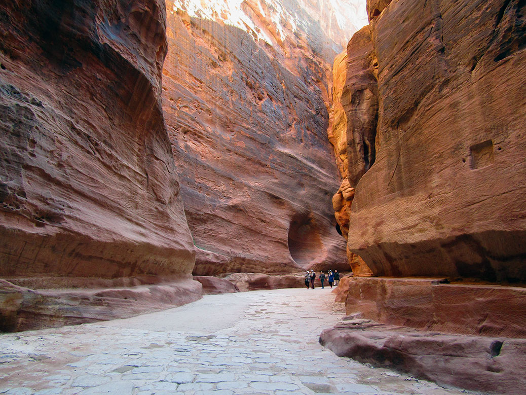
Before long, we arrived at a crack in the earth. The Siq, a natural passageway formed by a prehistoric earthquake, is as narrow as 10 feet wide and as tall as 600 feet. The sandstone canyon stretches more than a kilometer. It’s a walk through natural history with millions of years of layered sediment painting the walls. As the sun moves through the sky, the colors change from gold to rose.
In stretches, we also walked atop human history. Cobblestone roads installed by the Roman Empire during the 1st century AD are still visible. Remnants of 2,000 year old clay irrigation pipes line the sides of the wall, once providing water to the city.
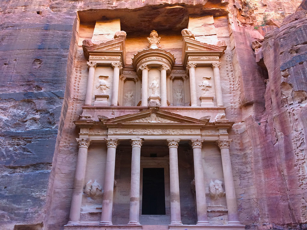
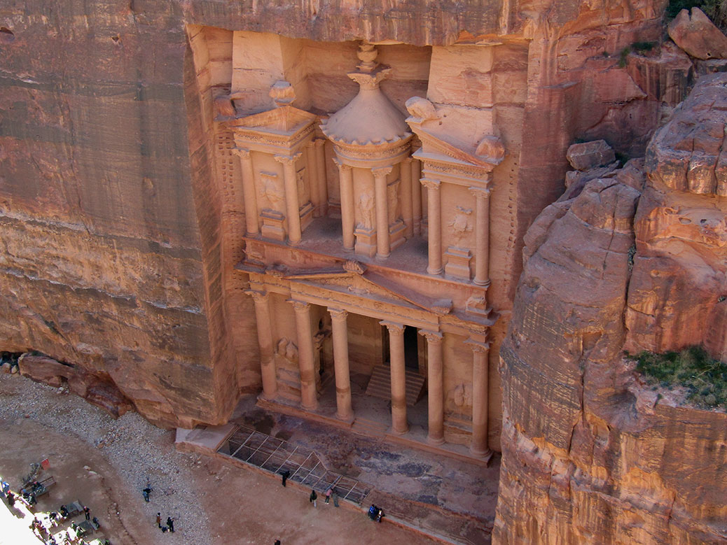
The Treasury
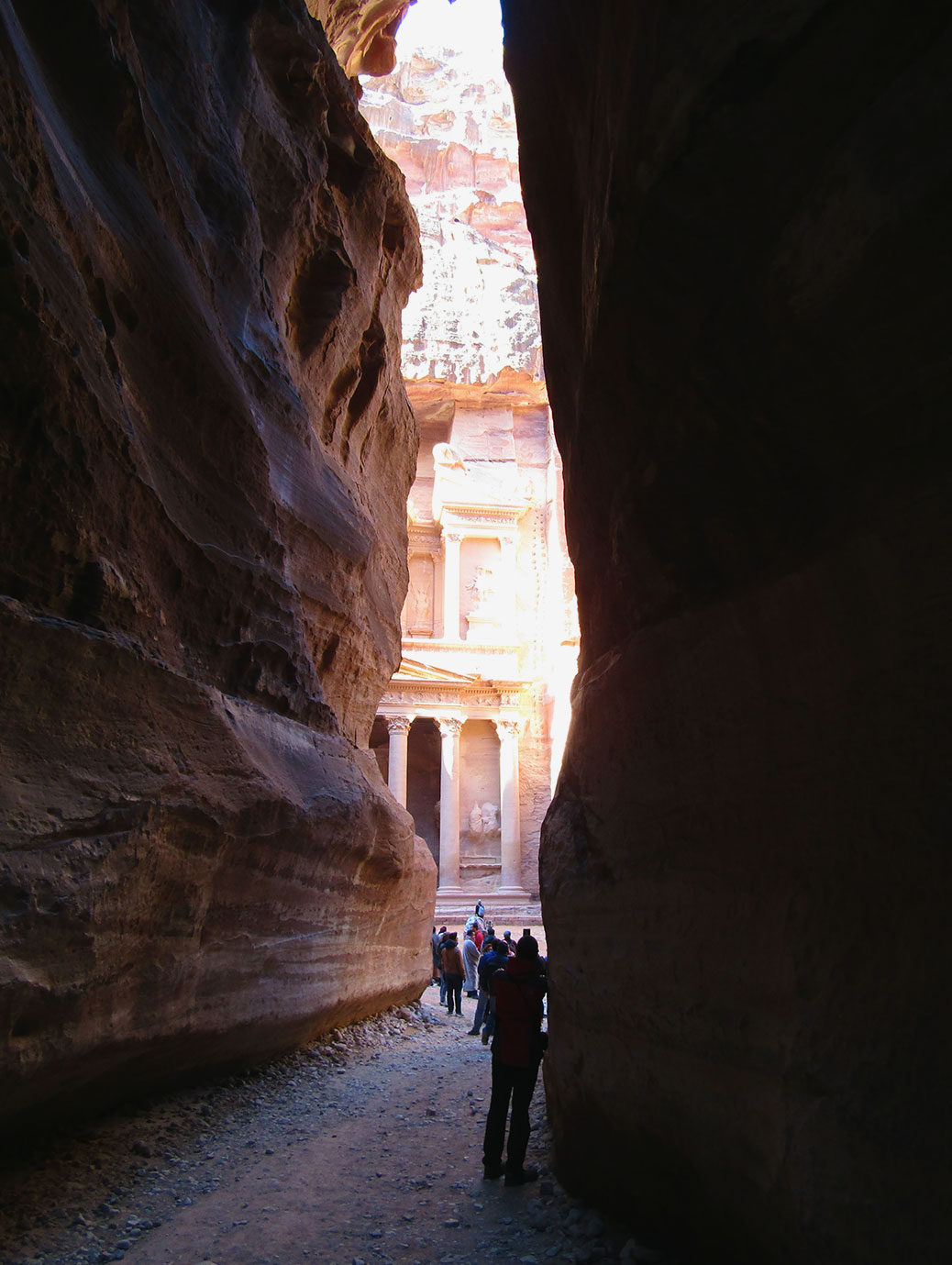
At the end of the Siq, we get our first glimpse of The Treasury.
As we approached the end of the Siq, we caught our first view of the main event. Al-Khazneh—better known as The Treasury—is Petra’s most famous building. Carved around the same time as the arrival of the Romans, its architecture is a mix of Nabataean and Greek Hellenistic influences. It began life as a mausoleum, but earned its nickname due to a local legend that the urn carved above the second floor contained gold. Bullet holes are still visible where local Bedouin tribes tried to shoot the gold free from its perch.
Looking down at the Street of Facades from the side of Al Kubtha Mountain.
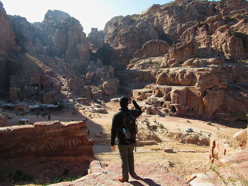
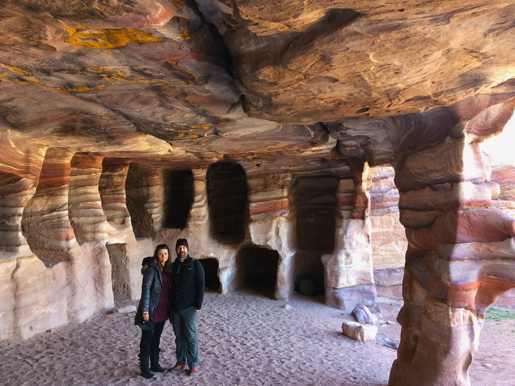
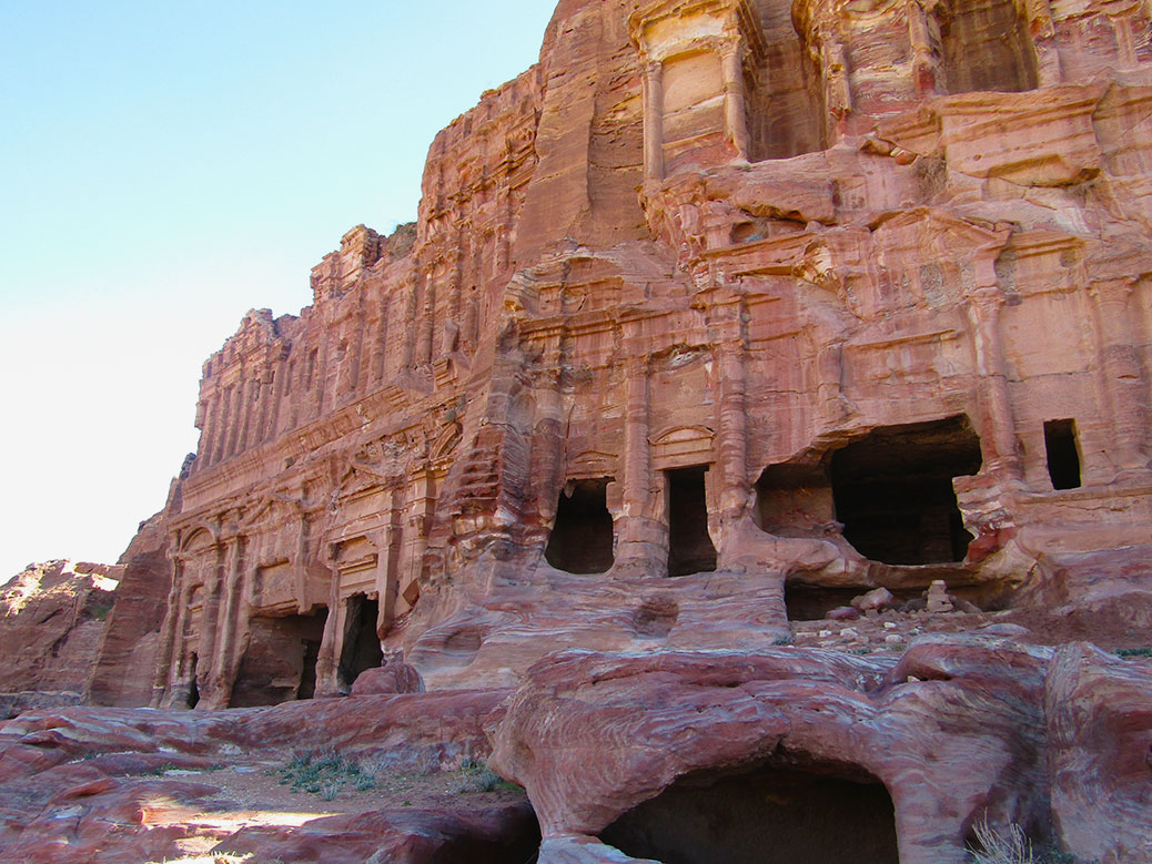
Continuing from the Treasury, we found ourselves entering the Street of Facades. The street is marked with tombs and false fronts framed by ornate facades. Instead of following the tour groups into the old city center, our fantastic local guide led us against the side of Al Kubtha Mountain. From here, we could peer into former tombs of the local people. Not unlike the carved caves that housed them, tombs were dug into the floors and walls.
The caves are the best place to get up close and personal with the history of Petra. Wall carvings from the people who have lived here over the past two millennia are still visible. We marveled at the natural artwork created by the layers of wind-swirled sand. Spectrums of reds, yellows, purples and earthtones provided decoration for living quarters and final resting places alike.
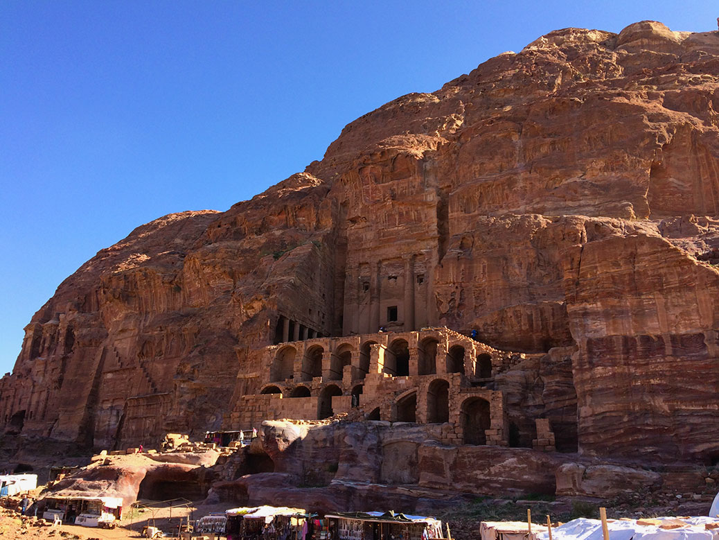
The Royal Tombs
Our guide led us around the corner where we came upon another set of buildings. Four Royal Tombs wrap around the northeastern end of Al Kubtha Mountain. The first is the Urn Tomb. With more depth than the previous facades, it was built for a Nabataean king—either Aretas IV or Malichus II—in the 1st century AD. Inside, inscriptions and asps designate the tomb’s conversion to a Catholic cathedral in the 5th century.
Nearby, the Silk Tomb, named for its richly-colored facade, slowly fades back into the sandstone. The neighboring Corinthian Tomb provides another example of Roman architectural influence with its embellished column design. The Palace Tomb sits attached, three-stories tall with a large stage in front. It’s facade is inspired by the Golden House of Nero in Rome.
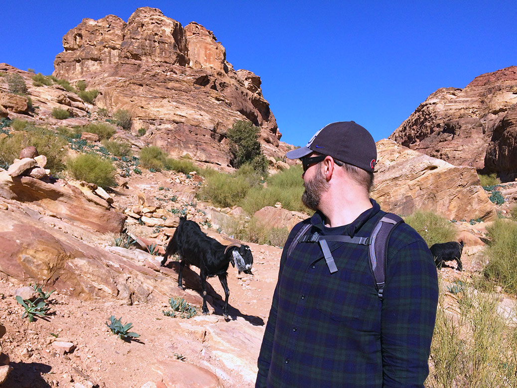
Top of the World
We encountered a herd of mountain goats near the top of Al Kubtha Mountain.
Our guide left us at this point with rough directions to the top of Al Kubtha Mountain. We climbed the long sandstone staircase to the top where we encountered a herd of mountain goats. With one eye on the goats, we made our way to the edge of the mountain where a Bedouin-style tent appeared.
Looking down at the Treasury from the High Place on Al Kubtha Mountain.
Inside, a man named Salem offered free views of the Treasury and reasonably-priced refreshments. We sat on the edge of the stone, our feet dangling over the ledge, and enjoyed a Coca-Cola. Salem played a song on his traditional shepherd’s flute, served as official photographer and defied death while jumping between the levels of rocks along the sheer cliff.
The People of Petra
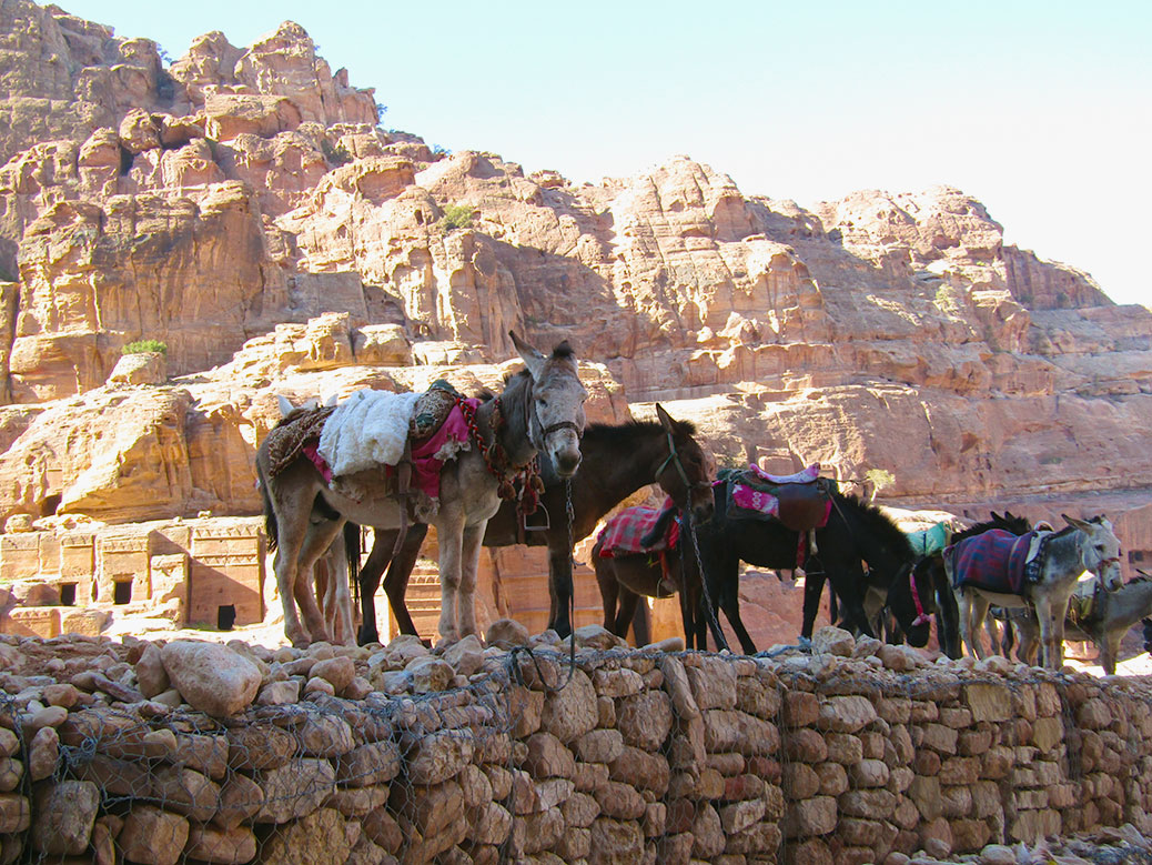
The real workers at Petra, donkeys and mules take a break in the shade near the Street of Facades.
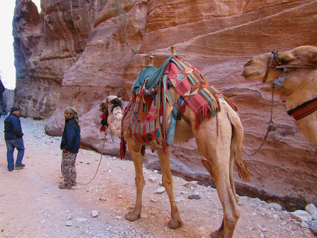
We began the descent back down the mountain, turning down the various offers of assistance from donkey wranglers. For the past two centuries, the nomadic B’doul tribe has called Petra home. Descendants of the Nabataean, the B’doul lived in Petra’s caves and—since the 1920s—made their living by selling goods, services and charisma to tourists.
The local B’doul tribe make their living selling souvenirs and offering donkey or camel rides inside Petra.
In 1985, UNESCO named the landmark a World Heritage Site. In an effort to keep the tribe from disturbing the newly-arriving tourists, the Jordanian government relocated the B’doul to a planned community in the nearby hills overlooking Petra. Three decades later, the neighborhood is overcrowded and underserviced, yet few B’doul want to leave their ancestral home behind. Even today, many serve as watchmen, keeping an eye over Petra throughout the night.
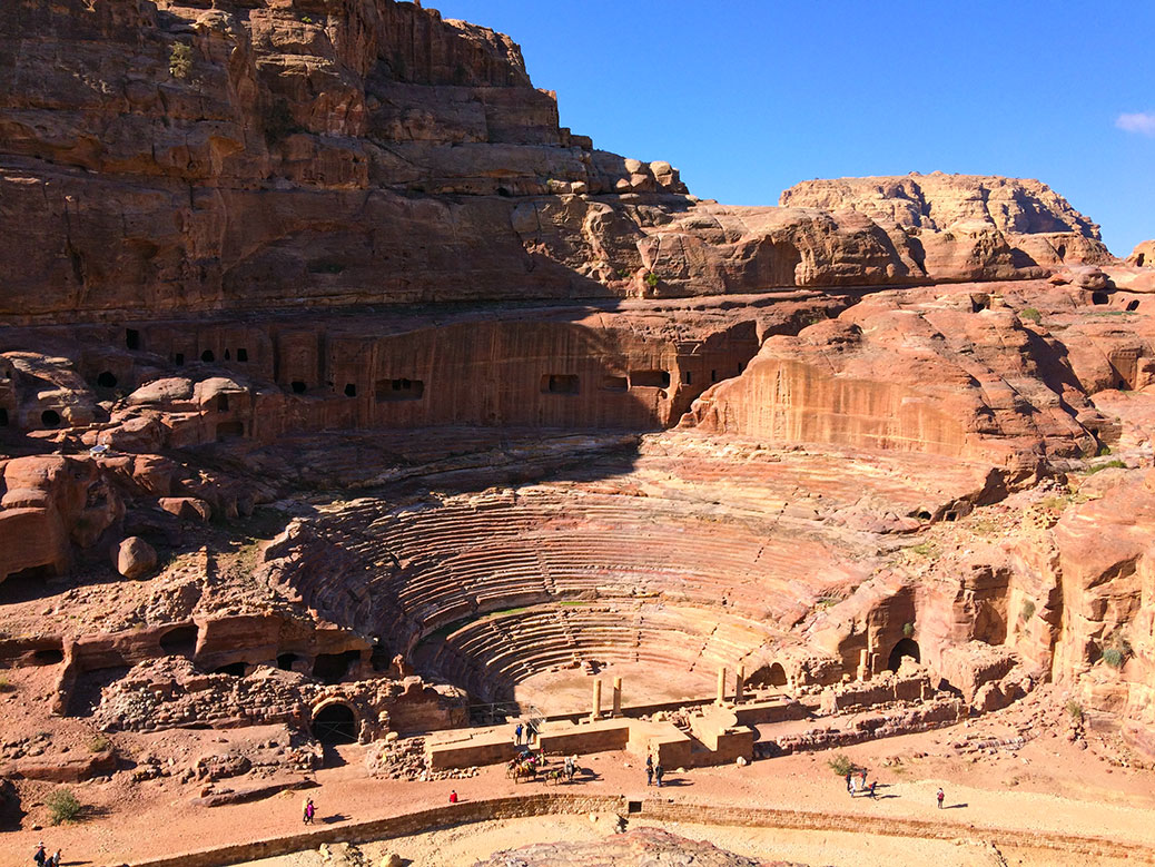
Petra is a rare glimpse into the daily life of an ancient culture. From the amphitheater in the city center to the Roman Colonnade Street, history comes to life in this place. A 5th century Byzantine Church, discovered under the sand in the early 1990s, shows that Petra was still a lively civilization long after most historians thought it deserted.
Today, 85 percent of Petra still waits to be uncovered. What other secrets exist below the desert sand?
To see something in person that you’ve only seen in photos can be a surreal experience, especially something as iconic as the Great Pyramid of Giza. The last remaining Wonder of the Ancient World rises like a mountain from the flat desert west of the Nile River. The glimpses caught through the tall apartment buildings that clutter the modern skyline are just a tease of the main attraction.
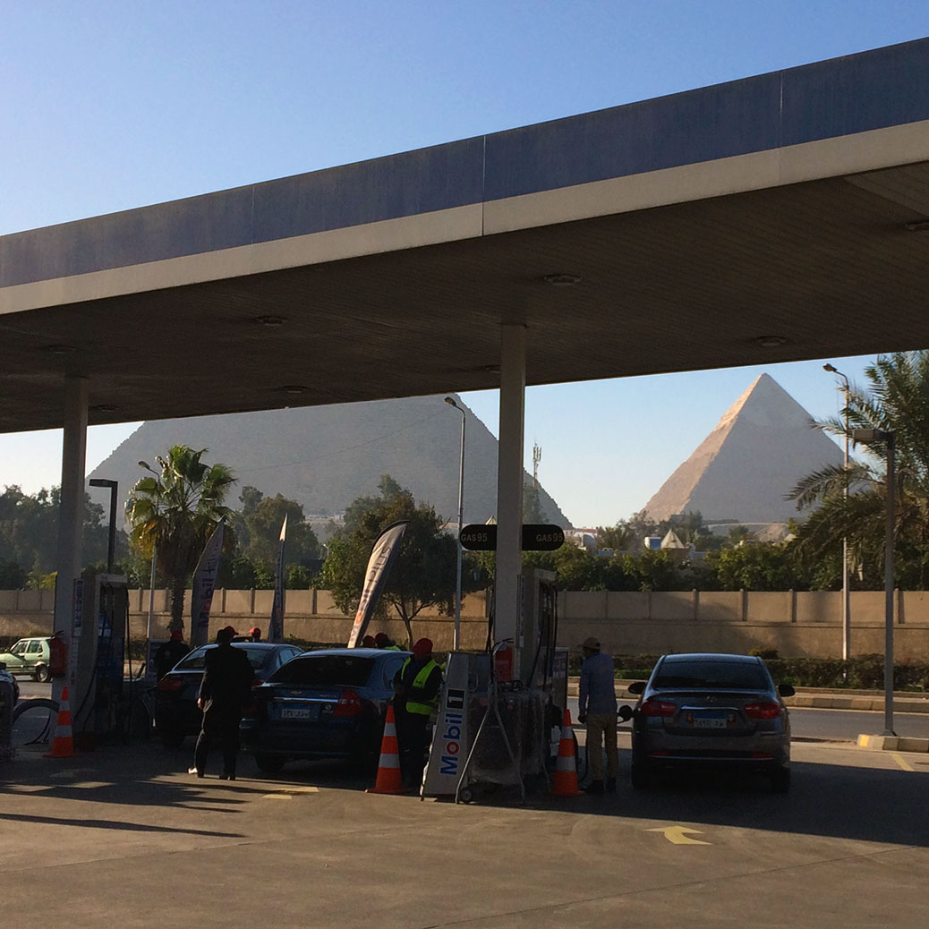
Our first up-close glimpse of the Pyramids came from a gas station… pretty good view while filling up the tank.
As we drove from Cairo toward Giza, it struck me how much the city encroaches on the plateau. The pyramids are typically photographed toward the west with the desert in the background. But just across the highway, the city has a front row seat to Ancient Egypt. So perhaps it’s fitting the roof of the On The Run gas station obstructed my first up-close view of the Pyramids.
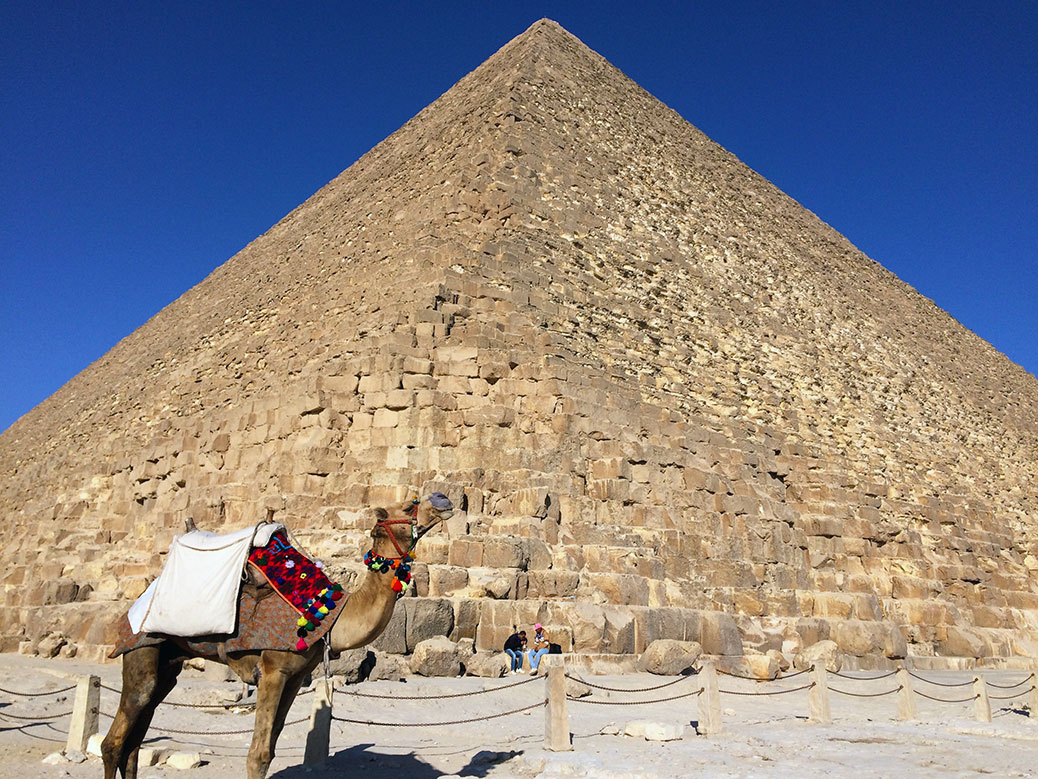
The Great Pyramid of King Khufu. From a distance, the pyramids seem smooth, but up close you can see the jagged exposed limestone of the pyramid’s core.
Only a moment later, we left modern-day Egypt behind. From a distance, the pyramids are smooth, three-dimensional triangles, but up-close, you get a sense of how they were born. More than 2 million stone blocks, each weighing more than two tons create a craggy surface. Once covered in white sandstone—some of which can still be seen atop the middle pyramid—the exposed core tells a story of the construction.
Thought to have been built by slaves, it’s now known that the pyramids were built by skilled laborers, revered and honored for their work in the form of statues found during excavations. Construction techniques still used today were applied here in 2500 B.C. Stones sit flush with perfectly-flat surfaces. Corner joints allow for heat expansion and movement during earthquakes.
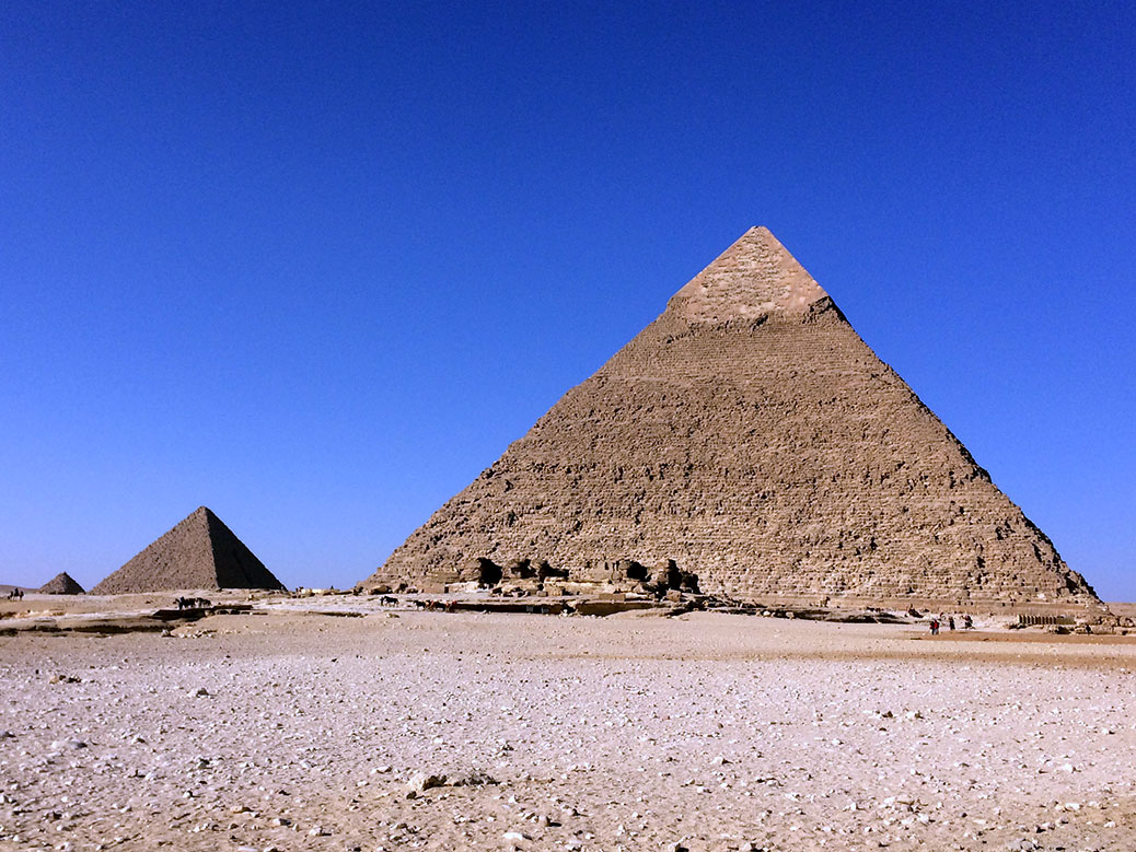
Khafre’s Pyramid and Menkaure’s Pyramid. In the distance, a smaller pyramid belonging to one of Khufu’s wives can be seen.
Pharaoh Khufu commissioned the three main pyramids of the Giza Pyramid Complex in the 26th century B.C. The Great Pyramid, the largest structure on Earth until the 1300s, is built in his honor. The middle pyramid—which appears largest because of its higher perch—is named for Khufu’s son and successor Khafre. The third and smallest pyramid belongs to Khafre’s son and successor, Menkaura.
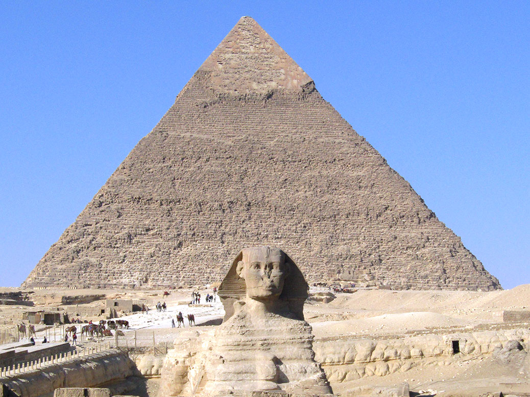
The Great Sphinx and Khafre’s Pyramid at the Giza Pyramid Complex.
The Great Sphinx is part of Khafre’s pyramid complex. With the body of a lion and a head believed to depict Khafre, workers carved the famous statue out of the limestone from the quarry used to build the pyramids.
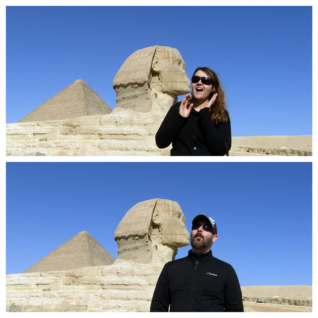
By all accounts, the Great Sphinx is a great kisser!
On the south side of the Sphinx, tourists gathered above the temple to pose for a variety of photos. The statue’s slightly puckered lips beg for a kissing photo. Not unlike Italy’s Leaning Tower of Pisa, part of the fun is watching visitors contort for the perfect picture.
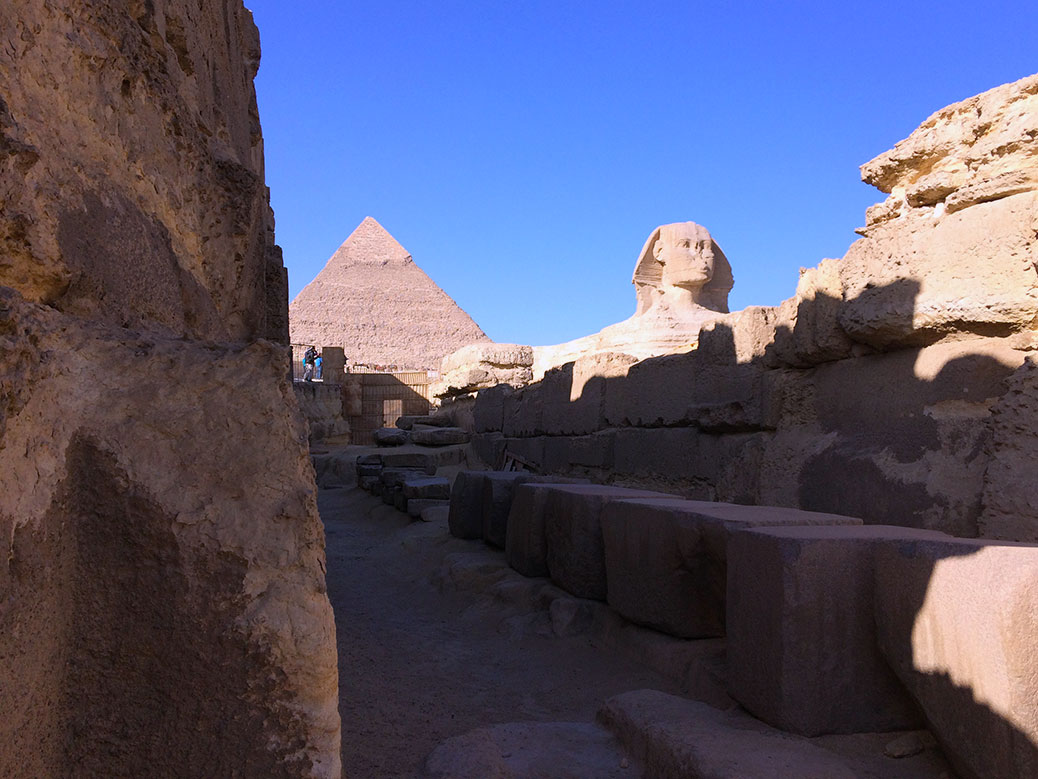
Coming around a corner near the entrance of the Sphinx Temple, the Great Sphinx and Khafre’s Pyramid peeked through the ruins.
Mohammed from Emo Tours served as our guide and site historian. He led us into the one of the sparsely populated temples where we caught a view of the Great Sphinx from below. With no other tourists around, it was a moment of solitude to really take in the experience.
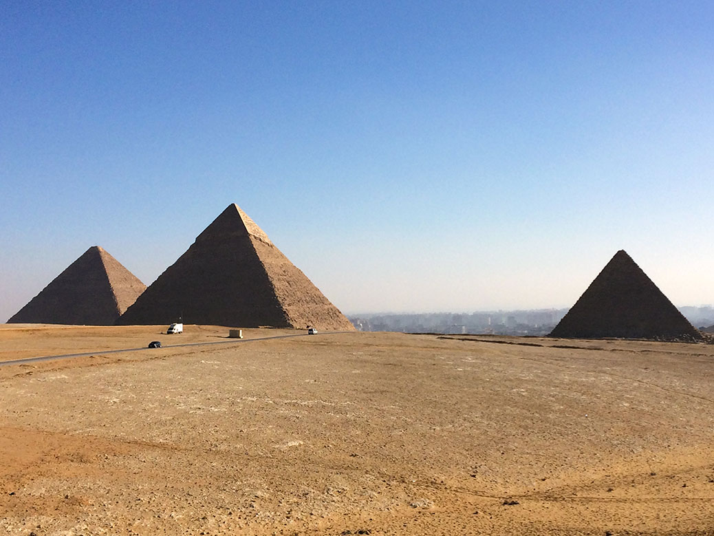
View of the three main pyramids from a northwest viewpoint.
We ended our visit at a northwestern viewpoint, looking back toward the pyramids with Cairo in the background. The blend of the ancient and modern worlds made me wonder what the pharaohs would think of all this? Did they ever imagine visitors from far away lands making a pilgrimage to this place? Or that their legacy would outlive nearly everything else from their time, to tell their story for generations to come?
If You Go
Emo Tours
Guided tours of Egypt’s top sightseeing locations and highly-rated on TripAdvisor.
For most visitors, Cairo is about pyramids, markets, museums and mosques. But after dark, the ancient city becomes a different place.
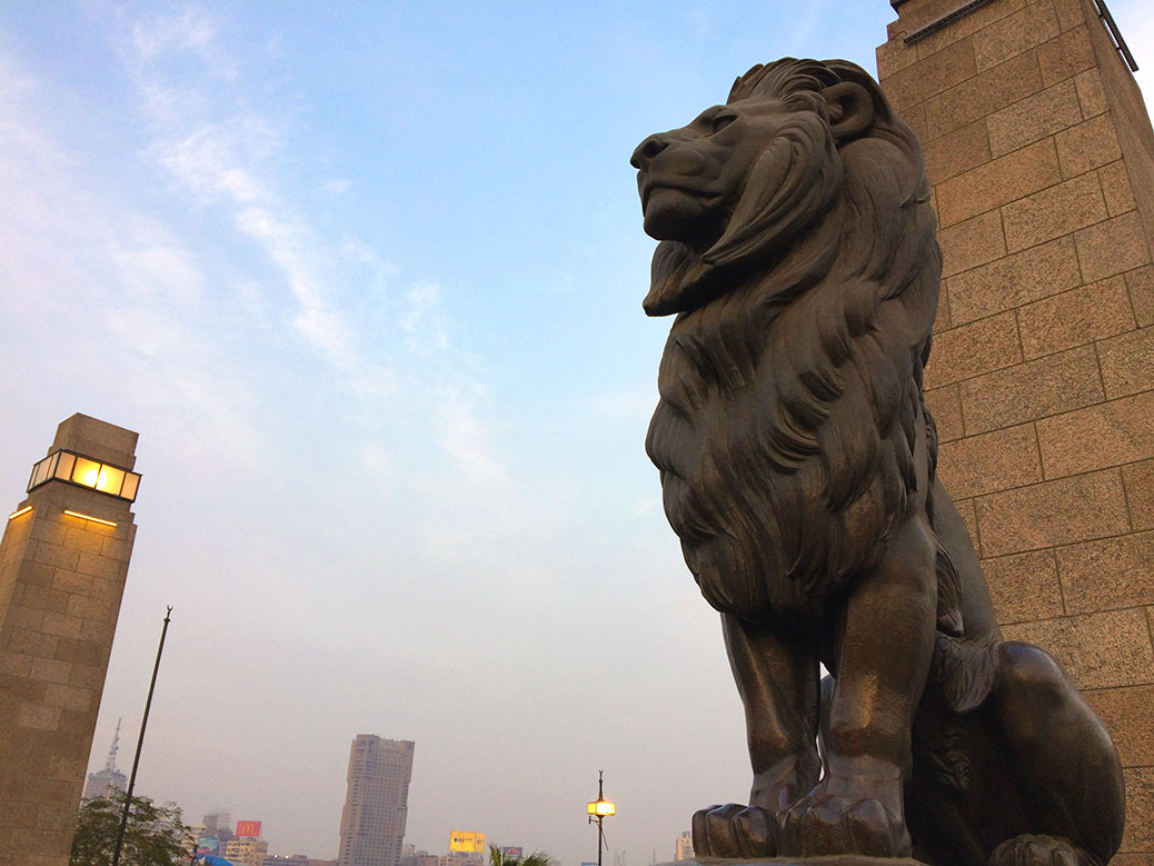
We followed Waleed, a guide with Cairo Urban Adventures(save $10 off your first Urban Adventures trip), on a four-hour trek through Downtown Cairo. Starting in the neighborhood of Dokki, we crossed the Nile River via the Qasr El Nil (translated: Palace of the Nile) Bridge, famous for its four bronze lions. The bridge lions, designed by 19th century French sculptor Alfred Jacquemart, guard in pairs at either end of the bridge. We’d previously seen Jacquemart’s work outside the Musee d’Orsay in Paris.
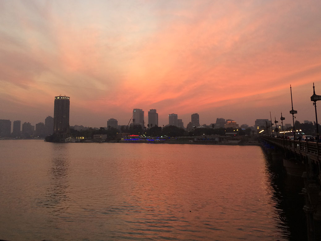
Sunset over the Nile River from the east end of the Qasr El Nil Bridge.
At the east end of the bridge, I dodged the chaotic traffic to take a photo of the fiery sunset over the river. Meanwhile, Viktoria was being approached by three Egyptian schoolgirls for a group selfie as the coral Egyptian Museum loomed in front of us.
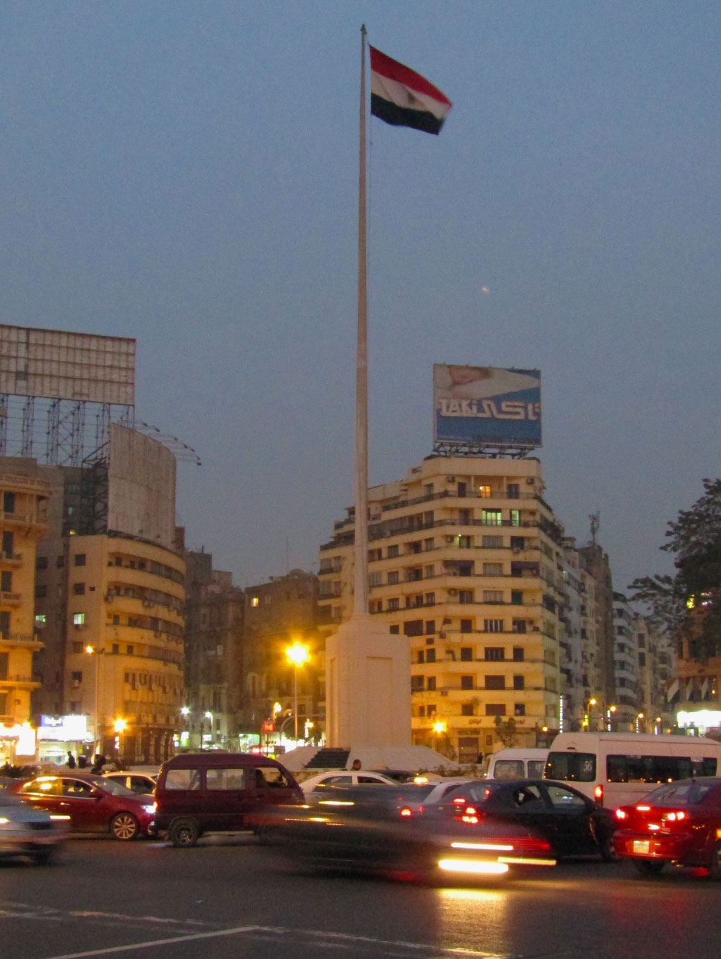
Tahrir Square at night
We continued toward Tahrir Square, the flashpoint of the 2011 Egyptian Revolution and 2013 protests. January 25 was the anniversary of the 2011 revolution. Depending on our destination, we’ll often act as our own tour guide, but one of the perks of local guides is hearing local stories.
Waleed shared his own experience of the revolution; of guiding a tour group out of the city before returning to take a “neighborhood watch” shift to protect his apartment building from rioters. He told of the internal struggle of wanting to be a part of the movement to end the corrupt 30-year reign of president Hosni Mubarak while also worrying for the safety of his father, a police officer serving in the heart of the square.
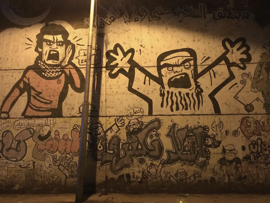
Graffiti from the 2011 Egyptian Revolution along Mohamed Mahmoud Street near Tahrir Square.
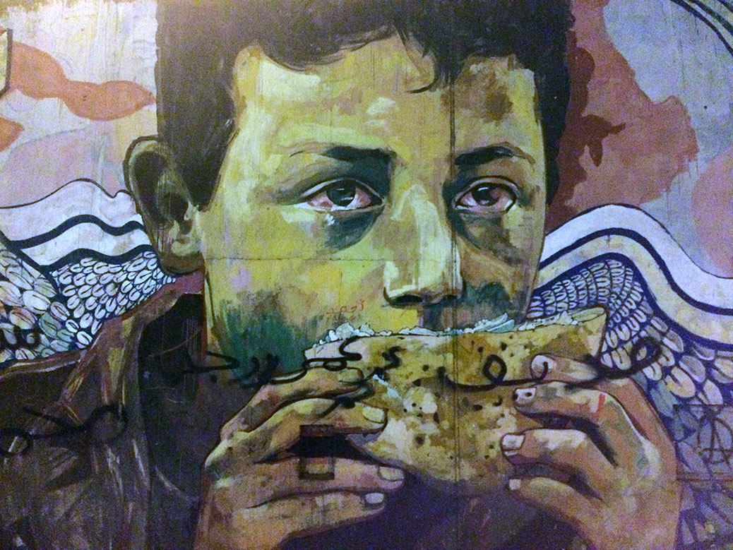
Today, it’s hard to picture 300,000 people gathered in the busy roundabout, but the marks of the revolution are still visible today. Outside the American University of Cairo, a single wall of graffiti from the 2011 revolution still stands today—the rest demolished in 2015 as part of a Tahrir Square renovation project. The simple image of a child eating a baladi bread sandwich flanked by a pile of skulls tells a powerful story, especially at night.
Graffiti from the 2013 protests depict the Muslim Brotherhood along Mohamed Mahmoud Street near Tahrir Square.
Nearby, a more complete collection of graffiti from the 2013 protests changes the story, depicting the ire against President Mohamed Morsi and the Muslim Brotherhood in a more comic style. Waleed led us through dark side streets, describing the meaning behind the images and the messages written in Arabic.
It was time to lighten the mood, which happened literally under the bright lights of historic Talaat Harb Street. After a couple hours of walking, it was time to eat, so we headed to Abou Tarek for koshari. Viktoria had already visited on a previous tour and it was on my must-eat list. I was not disappointed. The simple, filling national dish of Egypt can be found all over the city, but Abou Tarek is king.
After dinner, it was time for dessert and the last stop of our walking tour. We went to El Abd, one of Cairo’s most famous bakeries. Outside, people queue for house-made gelato. Inside, fresh-baked semolina cakes, phyllo-dough birds’ nests and other Egyptian sweets are up for grabs. Visitors elbow, shove and shimmy their way through the small, crowded shop. I found a nice gift box to take back to my co-workers in Cascadia.
We ended the night with one last adventure; Waleed lived in a neighborhood close to ours and offered to help us navigate the intimidating Cairo Metro. He bought our tickets for the equivalent of a nickel (five cents) and we boarded the train.
As the only foreigners on the Metro, the locals met us with friendly smiles and curious stares. We made small talk with a couple of young professional footballers on our journey back to Maadi. Waleed bid us farewell a few stops before ours, ending a great night in the real Cairo.
It’s been nine months since we left Japanand although we did some exploring around Cascadia, I haven’t had much opportunity for travel since Viktoria left for Cairo. Fortunately, a recent work trip took me to Pennsylvania and I stretched it into a weekend in Philadelphia.
I dropped my co-worker for an early flight, which gave me an opportunity to get a jumpstart on sightseeing. I dropped the rental car off at my Airbnb in the historic Italian Market neighborhood, put on my walking shoes and set out on the town. The unseasonably warm November weekend would be full of walking as the transit workers decided to go on strike, but we’ve had experience navigating a transit strike before, so I was good to go!
48 hours and 60,000 steps later, I checked off everything on my Philadelphia bucket list.
The South 9th Street Curb Market, better known as the Italian Market, has been home to produce stands, cafes and shops run by not just Italians, but immigrants from around the globe, since the late 19th century. Today’s market has an increasing Latin American influence.The beautiful Washington Park is home to the Tomb of the Unknown Revolutionary War Soldier memorial. Completed in 1957, a bronze statue of George Washington overlooks the remains of either a Colonial or British soldier.An icon of America, most stories around the Liberty Bell are more myth than fact. The truth is that the bell actually cracked during its first test strike and had to be recast twice. It was finally replaced in 1876.Independence Hall as seen from Independence Square where a crowd gathered for the first public reading of the Declaration of Independence on July 4, 1776.The Assembly Room in Independence Hall. The “Rising Sun” chair at the front of the room is where George Washington presided over the Constitutional Convention that drafted the United States Constitution.A sign outside the front door of Independence Hall, the birthplace of the United States of America.A view of the Christ Church Burial Ground from a window in the U.S. Mint building. Benjamin Franklin is the cemetery’s most famous occupantThe gravesite of Benjamin Franklin and his wife Deborah in Philadelphia’s Christ Church Burial Ground. Visitors leave pennies in honor of Franklin’s motto of “a penny saved is a penny earned,” but the combination of weather and the penny tosses have caused damage to the gravestone including the large crack.Outside the United States Mint. Photos aren’t allowed inside the largest of the Mint’s four coin-producing facilities. If your coin has a “P” or no letter, it was produced in this building!A statue of a lion squashing a snake in Rittenhouse Square, one of the original five public park spaces planned by William Penn in the late 1600s.Philadelphia’s City Hall was the world’s tallest habitable building from 1894 until 1908. Until the completion of One Liberty Place in 1987, builders in downtown Philadelphia had a “gentleman’s agreement” that no building would be taller than the hat of the William Penn statue atop the City Hall spire.Located across the street from City Hall is the Board Game Art Park, home to an installation of oversized board game pieces called “Your Move.”Since 1892, Reading Terminal Market has been the home to butchers, produce vendors and more. Today you can find Amish specialties and three shops run by descendants of original market vendors.The battle of the cheesesteaks… in this corner, Pat’s King of Steaks!… and in this corner, Geno’s Steaks!The rowhouse has been the domicile of choice in Philadelphia since the 1700s. Even today, nearly 60 percent of Philadelphians live in a rowhouse.Looking down South Broad Street toward Philadelphia City Hall early on a sunny autumn morning.Dilworth Park outside of Philadelphia’s City Hall has been transformed into a community skating rink for the holiday season.The Thinker sits outside Philadelphia’s Rodin Museum. Casts of the statue exist around the world today. We saw the original two-foot tall version in Musee Rodin in Paris during our travels around Europe.Since 1897, George Washington has kept watch over Eakins Oval in front of the famed steps of the Philadelphia Art Museum.The Lion Fighter, cast for the 1893 Columbian Exposition in Chicago, now stands outside the Philadelphia Art Museum.A statue of Rocky Balboa, cast for the movie Rocky III, stands in the shadow of the Philadelphia Art Museum. Several visitors ran up the steps, recreating the inspiring scene from the original Rocky movie.Boathouse Row lines the shores of Fairmount Dam on the Schuylkill River. The boathouses are home to 15 rowing clubs and is considered to be the home of rowing in the U.S.The neo-Gothic Eastern State Penitentiary operated from 1829 until 1971 and pioneered the modern approach of prisoner reform vs. punishment. The gargoyles are not permanent, but placed as decorations for the annual Halloween haunted house event, “Terror Behind the Walls.”A sign on St. Stephen’s Episcopal Church signifies that it was the site where Benjamin Franklin conducted his famous kite experiment, although the Historical Commission oval above it actually pays homage to the nearly 200-year-old church.A ship is moored in the Naval Inactive Ship Maintenance Facility at Philadelphia’s Navy Yard.
There are many things I miss about Japan, but festivals have to be near the top of that list. This weekend marks the 368th anniversary of the first Kawagoe Matsuri, the main festival event in our former hometown.
If you’re in the area, take some time and check it out. Kawagoe is less than an hour from Tokyo by local trains. In the meantime, enjoy our posts from the 2014 festival and the 2015 festival.
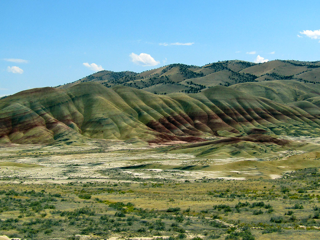
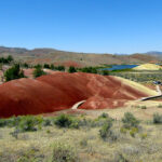
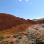
When most people picture Oregon, they see green fir trees, maybe snow-capped mountains or the Pacific Ocean. But 45 percent of the state is classified as desert and it is here where some of the most unique terrain in the state can be found.
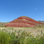
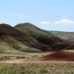
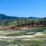
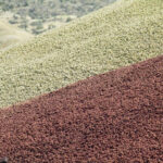
More than 200 miles east of Portland, the Painted Hills may be the most unique of all. Millions of years ago, the desert was covered by an ancient river that left a geological fairy tale behind in the rock and soil. Vibrant black, gray, red and gold soil layer the hills, colored by the prehistoric vegetation sediment from a time when the area was a hot and humid rainforest.
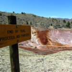
Located in the John Day Fossil Beds National Monument, the site is also important to archeologists. A bounty of fossils, the remains of early horses, camels and rhinoceroses, can still be found in the area.
Click any photo in the gallery to see a larger version and start a slideshow view
The first view of the hills as you enter the John Day Fossil Beds National Monument.
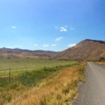
The road to the Painted Hills
Painted Hills
The hills from the viewpoint.
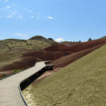
The boardwalk on the Painted Cove Trail.
The top of the Painted Cove Trail has panoramic views of the hills and the Painted Hills Reservoir.
The end of the Painted Cove Trail has panoramic views of the hills and the Painted Hills Reservoir.
The boardwalk around the Painted Cove Trail offers close-up views of the various layers.
Growing up in the Pacific Northwest, American colonial history is an afterthought. Our history is mostly natural or belonging to the region’s Native American tribes. But on the east coast, the birth of our country is on full display in every city and neighborhood. The backdrops of key moments in our nation’s history are now national parks, museums and monuments.
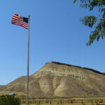
Situated on Baltimore’s Locust Point jutting into the Patapsco River, Fort McHenry is one of those places. The star-shaped fort played a major role in the War of 1812, but it is best known as the inspiration for “The Star-Spangled Banner.”
Over two days in September 1813, soldiers held off the mighty British naval fleet in the Battle of Baltimore. The standoff would become a turning point in the war for the American forces.
A statue of Francis Scott Key, author of the Star-Spangled Banner, greets visitors to Fort McHenry.
A young lawyer named Francis Scott Key witnessed the battle from the sea. Key was sent by President James Madison to negotiate the release of several prisoners, including Maryland physician William Beanes. Beanes was eventually released in part due to his willingness to care for both American and British soldiers during the war. The mission helped set a precedent for the rights of humanitarian workers in war zones.
The original draft of the Star-Spangled Banner in Francis Scott Key’s own handwriting is on display at the Fort McHenry visitor center.
On the morning of September 14, 1813, the results of the battle were still unknown. In the “dawn’s early light,” Key watched as the giant garrison flag—now on display at the National Museum of American History in Washington D.C.—was raised from the heart of Fort McHenry, indicating the fort had survived the battle. Inspired, he jotted the first draft of what would become The Star-Spangled Banner.
Did you know? The Star-Spangled Banner is sung to the tune of “To Anacreon in Heaven,” the official song of an 18th-century London gentleman’s club who gathered weekly for concerts, dinner and a lot of drinking.
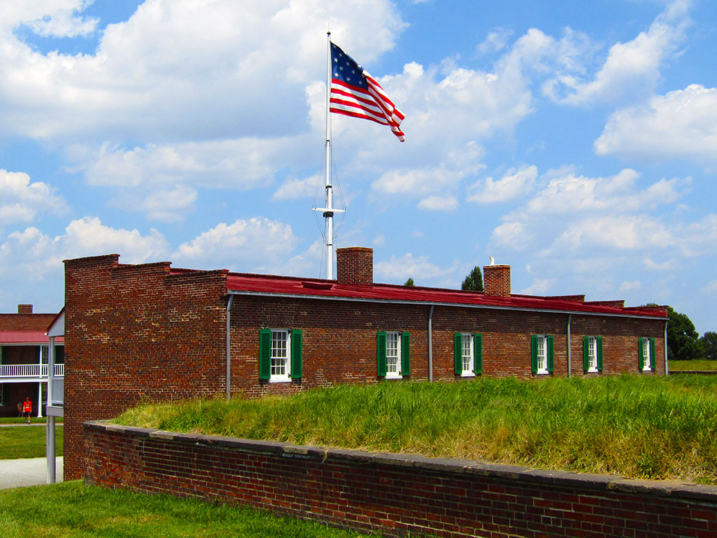
The garrison flag flies in the courtyard of Fort McHenry. The flag has 15 stars and 15 stripes, representing each of the colonies at the time. It was the only version of the flag with more than 13 stripes.
Today, the story of America’s national anthem is the main draw for visitors to the fort. The visitor’s center welcomes you with a small museum featuring artifacts from the war and displays about the evolution of the anthem in popular culture. A short movie offers a great crash course about the War of 1812 and how Key’s came to pen the anthem. At the end of the presentation, the screen recedes into the ceiling, revealing a window looking out to the fort and the massive garrison flag waving proudly while the Star-Spangled Banner plays.
During the park ranger-led Flag Talk, participants unfurl and hold a replica of the garrison flag that flies above Fort McHenry. At 30 feet by 42 feet, it required more than 30 people to hold it steady.
After the movie, we stepped into the oppressive summer heat for a Flag Talk. A young park ranger explained the story of the 30-feet by 42-feet flag as the gathered crowd unraveled a full-size replica. Holding the flag in your hands and seeing how many people it takes to keep it aloft is awe-inspiring. It’s a physical reminder of a time when Americans worked together for the survival of our country.
Women dressed in period costumes demonstrate how soldiers would have made dried pasta during the 19th century.
We wandered through the fort itself and watched as history came alive. Most of the buildings are open, including old bomb shelters, barracks and the armory. The claustrophobic feeling of life in the barracks is palpable. The armory building has a slight lean from British bombs. You can look out over the river and see the ghosts of the Royal Navy filling the horizon.
Fort McHenry is a physical reminder of another time. A time when Americans banded together for the common good. It’s a lesson regularly forgotten and relearned in times of tragedy. In these divisive times, it’s a good lesson to keep in mind…
What does the Star-Spangled Banner mean to you? How do you feel when you walk through historic sites like Fort McHenry? Head to the comments section below to take part in the conversation!
If You Go…
Fort McHenry National Monument and Historic Shrine
2400 East Fort Avenue, Baltimore. Follow the Fort McHenry signs on the freeway as many GPS directions are incorrect. Admission to the fort is $10 for adults age 16 and older and is valid for seven days. The visitor center, museum and informational movie appear to be free.
Reaching the summit of Japan’s iconic Mount Fuji is often on the short list of activities for visitors, but few realize the small window of opportunity for novice climbers. At more than 12,000 feet of elevation, the terrain is only passable for about 8-10 weeks from mid-July to early-September.
The view of the sunrise from the summit of Mount Fuji makes climbing through the night all worth it.
Reaching the Top
The top of Japan’s tallest peak can be reached a few different ways, but most climbers attempt to arrive at the summit for the sunrise. Arriving by 4:30 a.m. requires climbing during the middle of the night. While it’s possible to make all of the arrangements yourself, it’s much simpler to book a tour through one of the many companies leading both local and foreign visitors to the top.
We made our summit in August 2014 and chose Willer Express as our travel company. With daily tours departing from near Tokyo’s Shinjuku Station, Willer Express provides bus transportation to and from Fuji’s 5th Station, an English-speaking guide, mountain hut lodging at the 8th Station, three meals and a visit to an onsen (hot springs).
Gear Up
With the 90ºF temperatures of the Tokyo summer, it’s hard to imagine you could be fighting off hypothermia less than 24 hours later. Having the right gear may be the most important consideration in making the climb an enjoyable experience.
Most tour companies offer an affordable gear package, which can be convenient for novice climbers or those traveling light. If you bring your own gear, consider the following items at a minimum:
Lightweight daypack with rain cover. Bring a bag just large enough to carry your gear. From Tokyo to Fuji’s summit, you’ll experience a 40-60ºF decrease in temperature, so you’ll need to be able to swap gear on and off along the way.
Waterproof jacket and pants. When it rains, it pours. Literally. On our summit, it started raining about 20 minutes before we reached the mountain hut at Station 8. By the time we arrived, we were soaked to the bone, even with our rain gear. Hut employees won’t allow you inside until you are dry and will greet you with leaf blowers and towels to keep the rainwater outside.
Waterproof hiking boots/shoes. With the steep ascent and descent, you’ll want properly-fitting hiking shoes with good traction. I’d recommend buying these beforehand and testing them in the wild rather than renting an ill-fitting pair of shoes on the morning of the climb. A pair of gaiters isn’t a terrible idea either to keep rain from entering via the tops of your shoes.
Cold-weather clothing. Poor clothing choices are one of the most common mistakes made by Fuji first-timers. Average temperatures at the summit are around 40ºF, but can feel much closer to freezing due to wind chill and the aforementioned rain. Dress in layers so you can add and remove as needed during the climb.
The terrain on the ascent of Mount Fuji varies from flat, volcanic rock to steep, rocky peaks. The right gear will make your experience all the more enjoyable.
Hiking poles. Poles aren’t necessary for the ascent, but will come in handy on the long, steep descent. You can purchase a souvenir wooden pole and can have it stamped at each of Fuji’s stations to mark your progress. Make sure you have gloves if you choose the wooden pole as it’s more for looks than utility.
Hats. You’ll be climbing both in the sun during the day and in the cold at night. Consider a brimmed hat for keeping the sun away and a hat that will cover your ears for early-morning climbing.
Gloves. Bring warm, durable, waterproof gloves with good grip. I had warm gloves, but once they were wet, they were no longer warm. You’ll also be using your hands a lot near the final ascent to the summit, so they’ll need to stand up to sharp rocks.
The view from our hut window around 1 a.m… a never-ending string of headlamps joining us for the climb to the summit
Headlamp. You’ll need your hands free to navigate the rocks near the summit, making a headlamp a better choice than a handheld flashlight. One of my favorite sights was waking up at the mountain hut at 1:30 a.m. and seeing the endless headlamps coming up the trail behind us.
Sunglasses/sunscreen. Fuji is exposed to all the elements, especially the sun. Bring a good quality sunscreen and UV-blocking sunglasses.
Water and snacks. Our tour company recommended three liters of water per person for the entirity of the climb. You can carry it all with you or bring one and purchase additional bottles at stations along the way. While it’s more economical to bring your own, it might be worth the extra yen to lighten your load.
Change of clothes. Bring a change of clothing and shoes, especially if you choose a package that ends with an onsen visit. The ride back to Tokyo will be much more pleasant in a clean outfit.
Japanese yen. Mount Fuji is one of the few places in Japan where you’ll find pay toilets. At 200-300 yen ($2-3 USD) per turn, you’ll want to budget accordingly. You can also buy additional water, snacks and gear at each of the stations. Japan is a very cash-oriented society, so carrying large amounts of money is not unusual.
Camera and extra batteries. The views on the mountain are breathtaking and you’ll have plenty of opportunities to take photos. I don’t recall electrical outlets in the mountain hut, so make sure you have extra batteries or a portable charger.
Extras. If you are prone to elevation sickness, oxygen canisters can be purchased along the way, but you might consider bringing one with you in case canisters are sold out. In our group, the first case of elevation sickness from the thin air showed up around the 7th Station.
The sleeping arrangements in the mountain huts are cozy and booked solid. Be prepared to make some new friends!
Tips
Stash your extra clothes, shoes and gear at the 5th Station. There are coin lockers at the 5th Station. I wish I’d stashed a complete set of dry clothes, including shoes, in one of those lockers. While the onsen was great, it was awful having to put wet clothes on afterward. It’s also a cheap way to lighten your load up the mountain.
Take the tour. Definitely spring for the tour company (we used Willer Express and would recommend them again) and take them up on their entire rental package. Mountain hut reservations often fill up quickly, but the tour companies have standing reservations.
Prepare for the rain and cold. I had a base layer, cotton shirt, DriFit pullover, fleece jacket and rain jacket and my teeth were still chattering at the summit. My gloves were soaked and freezing. My two layers of socks were the only thing standing between my toes and frostbite. Choose layering clothes as the temperature difference between the 5th Station and the summit is pretty extreme.
Check the calendar. The climbing season is short. If you’re planning to climb Fuji, make sure to schedule your trip between early July and mid-September. While you can still climb in the off-season, shops and huts are closed and trails are not maintained and the ascent can be dangerous for inexperienced climbers.