When most people picture Oregon, they see green fir trees, maybe snow-capped mountains or the Pacific Ocean. But 45 percent of the state is classified as desert and it is here where some of the most unique terrain in the state can be found.
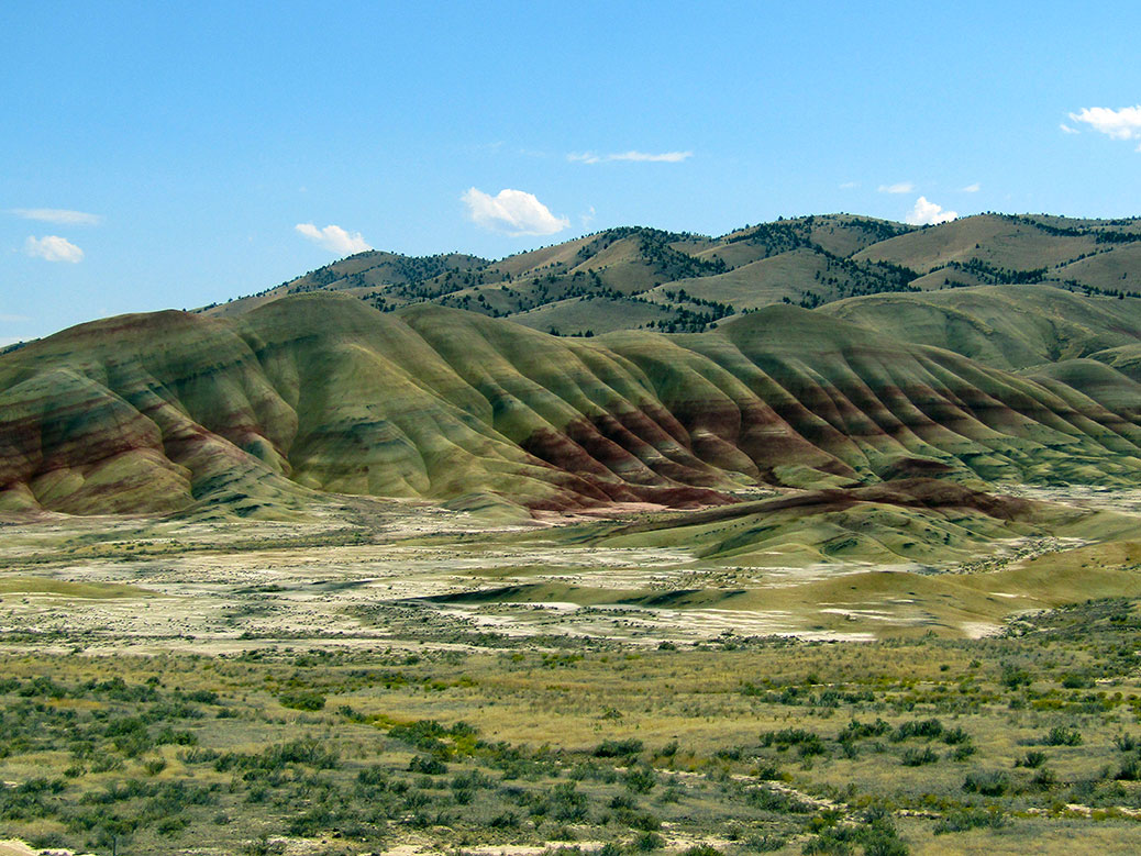
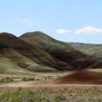
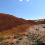
More than 200 miles east of Portland, the Painted Hills may be the most unique of all. Millions of years ago, the desert was covered by an ancient river that left a geological fairy tale behind in the rock and soil. Vibrant black, gray, red and gold soil layer the hills, colored by the prehistoric vegetation sediment from a time when the area was a hot and humid rainforest.
Located in the John Day Fossil Beds National Monument, the site is also important to archeologists. A bounty of fossils, the remains of early horses, camels and rhinoceroses, can still be found in the area.
Click any photo in the gallery to see a larger version and start a slideshow view
The first view of the hills as you enter the John Day Fossil Beds National Monument.
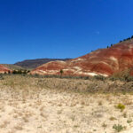
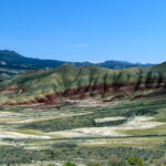
The road to the Painted Hills
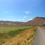
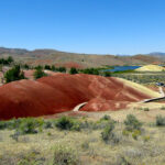
Painted Hills
The hills from the viewpoint.
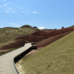
The boardwalk on the Painted Cove Trail.
The top of the Painted Cove Trail has panoramic views of the hills and the Painted Hills Reservoir.
The end of the Painted Cove Trail has panoramic views of the hills and the Painted Hills Reservoir.
The boardwalk around the Painted Cove Trail offers close-up views of the various layers.
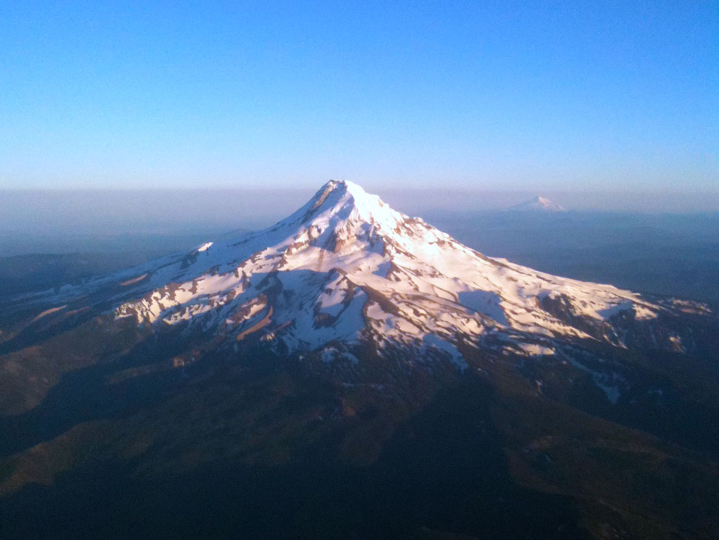
Growing up in the northern end of Oregon’s Willamette Valley, it was easy to take the majesty of Mount Hood for granted. The glowing beacon in the east filled the horizon while effortlessly blending into the background.
Looking at the northwest face of Mount Hood from the Hood River Bridge.
It was only after moving away from the Valley that the iconic mountain became something more. When I’d drive home from college, it was the mountain that told me I was getting close. Living in Japan in the shadow of Mount Fuji, I would always be reminded of Mount Hood and how lucky I was to experience two of the world’s great natural creations on a regular basis.
Mount Hood might be the quintessential Oregon image with its perfectly pointy, snow-covered peak. But in true Oregon fashion, the natural beauty is just the first of many layers that tell the whole story of the mountain the Multnomah tribe called Wy’east.
At just over 11,000 feet, Oregon’s tallest mountain is also a semi-active volcano. Recent earthquake swarms, while common, served as a reminder that Hood is Oregon’s most likely candidate for a volcanic eruption, last bursting in 1865.
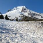
The summit of Mount Hood is mostly free of snow by mid-spring.
Eruption concerns don’t keep the visitors away. During the winter, Mount Hood is the ultimate playground for snow sports. Snowboarders and skiers come from around the world to tackle the miles of trails at Mount Hood Meadows, Timberline and Skibowl, home to the largest night skiing area in the U.S.
The surrounding national forest keeps things busy during the dry season, with more than 1,000 miles of hiking trails and 140 miles of mountain biking trails. We recently tackled a pair of gorgeous hikes, including the family-friendly Mirror Lake trail. The three-mile in-and-out hike slowly gains 700 feet of elevation via switchbacks from the trailhead to Mirror Lake. Views of Mount Hood’s peak reflecting in the aptly-named lake are simply breathtaking.
In the afternoon, we tackled a good portion of the seven-mile Ramona Falls trail. Crowds thin out after the first mile where the trail crosses the Sandy River. The bridge over the river was destroyed in a rainstorm in 2014 and has not been replaced, requiring hikers to brave the crossing via fallen tree trunks. Around mile three, the trail connects with the famous Pacific Crest Trail, leading to the wide, cascading waterfall.
Click any photo in the gallery to see a larger version and start a slideshow view
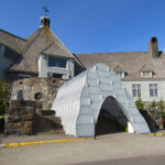
Historic Timberline Lodge near the summit of Mount Hood. The “cave” protecting the stairs from the snow was still in place in June.
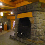
The multi-floor fireplace in the Timberline Lodge lobby. The 90-foot chimney serves as the top of the iconic tower outside.
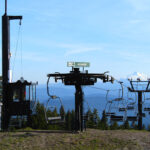
View of Mount Jefferson from Bruno Ski Lift on Mount Hood.
The snow-covered summit of Mount Hood begins to melt by early June.
With all the physical activities, it’s no surprise that the area also offers plenty of opportunities for relaxation. Timberline Lodge is among the most popular stops for tourists visiting the mountain. The National Historic Landmark was originally a project of the Works Progress Administration as a way to put people back to work after the Great Depression. The 40,000 square-foot lodge was finished in 1938 and dedicated by President Franklin D. Roosevelt himself.
Today, the lodge draws in freezing skiers and snowboarders who surround the six-sided, two-story fireplace in the lobby. A small museum tells the story of the construction and restoration of the lodge and includes displays of Native American art, artisan-built furniture and even Roosevelt’s chair. As a child of the 1980s, I was most impressed to learn that the drawing of the skier on a chairlift on the orange Pee-Chee folder was taken from a photo on Timberline’s “Magic Mile” chairlift. The photo of Merrie Douna riding the world’s second chairlift was also featured in a 1948 issue of Life magazine.
For out of town visitors, Timberline’s connection to popular culture is a major draw. The exterior of the lodge was featured in the 1980 Jack Nicholson classic The Shining as well as the film adaptation of Cheryl Strayed’s best-selling novel Wild.
On a warm day, a stop into the Mt. Hood Brewing Co. taphouse just off of Highway 26 in Government Camp is worthwhile. Six flagship brews and a handful of seasonals are served on a frozen rail built into the bar, invoking the feeling of winter even in the dog days of summer.
Timberline Lodge
From US-26, follow signs for Timberline Lodge. The lodge is open 24 hours. Check websitefor restaurant and lift hours.
Skibowl
From US-26, follow signs for Skibowl. See website for seasonal hours.
Mirror Lake Trailhead
On US-26, look for the roadside parking area about two miles west of Government Camp. A Northwest Forest Pass is required, but day passes can be purchased from stores on US-26. Family-friendly.
Ramona Falls Trailhead
From US-26, turn left onto E Lolo Pass Rd near Welches. Turn right onto Forest Road 1825 and turn right across the bridge in about a half-mile. Follow narrow road to large parking area. A Northwest Forest Pass is required, but day passes can be purchased from stores on US-26. Due to the dangerous river crossing, this is not a family-friendly hike.
The sprawling plateau of central Oregon’s high desert region is one of North America’s great adventure sports destinations. Mt. Bachelor tests experienced snowboarders and skiers during the winters. The Deschutes River draws rafters, kayakers and paddleboarders all summer long. Sprawling trails offer mountain bikers, hikers and trail runners endless possibilities.
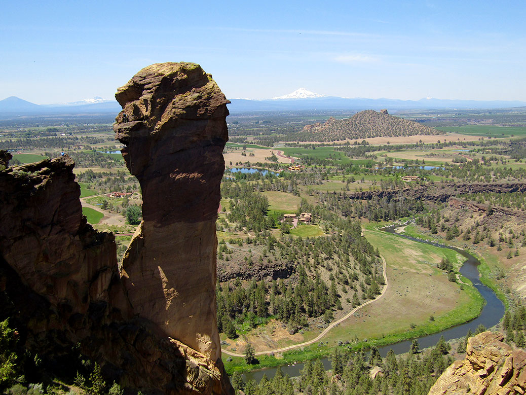
A few miles north of Bend—central Oregon’s largest city—Smith Rock calls rock climbers from around the globe to the precipitous cliffs of its volcanic tuff. Carved out over the course of 30 million years by a collapsed volcanic crater, lava flows and finally shaped by the aptly-named Crooked River, the formation stands out from the surrounding flat farmland.
Smith Rock is widely known as the sport climbing capital of the world. More than 500 climbing routes provide opportunities for beginners and elite climbers alike. However, it was the challenging hiking trails that led us to the rock on a warm and sunny spring day.
The Crooked River helped shape the current geography of Smith Rock.
Even during the middle of the week, the ample parking area was full. A small interpretive center is surrounded by a shaded picnic area leading to the trailhead. Views from the top of the ridge are spectacular. The Crooked River winds through the formation while Mt. Washington with its distinctive pointed summit peeks out from a dip in the jagged rock.
Two paths lead from the parking area to the various trailheads. The subtle Canyon Trail takes a long loop along the rim walls down to the footbridge. The steep and rocky Chute is a straight shot for those hikers anxious to hit the trail.
Looking south toward Monkey Face from the River Trail at Smith Rock.
Across the bridge, two family-friendly trails offer an easy walk with great views of the cliffs and a front-row seat to watch the dozens of climbers attached to the walls. The mile-long Wolf Tree Trail follows the north end of the canyon while the 2.5-mile River Trail heads south and provides the best look at the famous Monkey Face.
The Misery Ridge trailhead follows steep switchbacks to the summit around 1,000 feet above.
Wanting more of a challenge, we went straight ahead to the Misery Ridge Trail. The steep and rocky switchback trail is less than a mile to the top, but difficult as it covers 1,000 feet of elevation gain on a narrow trail. Along the way, tiny dots of climbers cling to any available wall, leaving our legs weak just looking at them.
Looking north toward the Crooked River from the summit of the Misery Ridge Trail.
We approached the summit of the Misery Ridge Trail, encountering a few climbers who took the “easy” way to the top. We looked back at the challenging climb from the stone plateau where the Crooked River meandered below. We dared ourselves to take in the view, staying a safe distance from the edge of the sheer cliff.
Looking toward Mt. Bachelor and Three Sisters from the Misery Ridge Trail summit.
On the opposite side of the summit, the viewpoint opens up over the nearby cities of Redmond and Bend, all the way to the Cascade Mountain Range. We sat for awhile with a group of hikers from the Salem-area and watched as climbers tackled Smith Rock’s iconic Monkey Face.
Climbers descend Monkey Face.
Monkey Face is a 350-feet-tall rock spire that appears ready to topple at any time. Climbers ascend via multiple routes, including one known as Just Do It, considered one of the toughest free-climbing routes in the world. During our visit, the climbers descended over the monkey’s nose, resting on the mouth before dangling from their ropes and slowly lowering themselves to the rocks below.
A bald eagle soars majestically over the Mesa Verde Trail.
Misery Ridge connects to the Mesa Verde Trail for the descent with equally-steep switchbacks over loose gravel. The slow shuffle to the bottom took about an hour to cover just a mile, although we stopped for awhile to try and capture a photo of a bald eagle that swooped overhead.
A hummingbird zipped in and out of the grass near the river.
At the bottom, the trail levels out as it connects to the River Trail. We stopped repeatedly to take in the southern view of Monkey Face, where its namesake details are most visible. The River Trail expectedly follows the Crooked River back to the beginning of the trailhead.
Just when you think you’re done, a steep climb up The Chute or the Canyon Trail stands between you and your return to the top. We enjoyed a picnic lunch before making the long drive back to Portland.
If You Go…
Smith Rock State Park
From Bend, follow US-97 toward Terrebonne. Turn right on NW Smith Rock Way and left on NE 1st Street. Turn left on NE Crooked River Dr and follow the road to the parking area. Day use parking is $5 or free with an Oregon State Parks parking permit.
Misery Ridge Trail 3.7 miles, steep and rocky with about 1,000 feet of elevation gain. From the main parking lot, follow any trail toward the canyon. Take the Canyon Trail or The Chute across the footbridge and up the switchbacks at the trailhead marker. From the Monkey Face viewpoint at the summit, head down the left side toward the switchbacks connecting to the Mesa Verde Trail. As you approach the river, continue straight on the trail to connect to the River Trail and follow back to the trailhead at the footbridge.
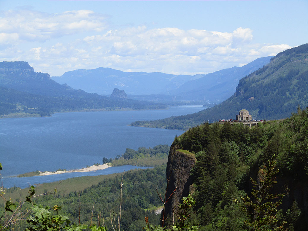
Driving east on Interstate 84 from Portland, Ore. lies 80 miles of one of the most beautiful stretches of nature on the planet. Still largely undeveloped, the Columbia River Gorge is a playground for both locals and more than 3.5 million tourists annually.
The Gorge was formed over the course of 15 million years as the mighty Columbia River slowly eroded away the rock. Floods from the end of the Ice Age carved out the most dramatic features, exposing beautiful layers of volcanic rock. Looking at the Gorge today, with the river flowing strong some 4,000 feet below the top of the cliff walls, it’s a powerful image to imagine what it may have looked like as nature took its course.
On a recent sunny spring day, we headed for this natural wonderland, ultimately bound for the small town of Hood River. It didn’t take long to ditch the interstate for the more scenic Historic Columbia River Highway. The first planned scenic highway in the U.S., today’s HCRH runs for 40 miles through the forest, offering a gateway to many of the 90 waterfalls along the Oregon side of the Gorge.
Looking east from the Portland Women’s Forum State Scenic Viewpoint toward the Vista House on Crown Point and down the Columbia River Gorge.
Our first stop was the Portland Women’s Forum State Scenic Viewpoint, providing the most photographed view of the Columbia River Gorge. Just up the road, the Vista House at Crown Point unofficially marks the beginning of the Gorge. Built in 1916-18 as a resting area for the new highway, it now houses an excellent museum featuring the natural and human history of the Gorge.
Continuing east on the HCRH, rows of cars begin to appear on the shoulder of the narrow two-lane road. The waterfalls in this stretch—the most concentrated in all of North America—are the main draw for day-trippers from Portland looking to hike the scenic trails or just stop for photos or a picnic. Many of the falls are accessible by a short walk from the road or nearby parking lots.
Multnomah Falls is Oregon’s tallest waterfall at an estimated 620 feet tall. It flows year-round, making it a popular tourist destination all year long.
The biggest crowds are reserved for the magnificent Multnomah Falls. Oregon’s tallest waterfall drops in two parts—a long upper falls that collects into a basalt basin, giving way to a shorter lower falls. The best view is in front of the lower basin looking up at the footbridge, but a short walk up to the bridge is worthwhile.
Hiking to the top is a difficult march through steep switchbacks, but the views are worth it. You’ll also be rewarded with another waterfall—Little Multnomah—that can only be seen from the top.
From here, we followed the HCRH back to I-84 toward Hood River. Even on the modern freeway, there’s no shortage of sights along the way. The community of Bonneville is best known for the massive Bonneville Dam. Built in the 1930s as an initiative of the New Deal’s Public Works Administration, the dam provides power to more than 500,000 homes. It was named a National Historic Landmark in 1987.
Further up the river, the Bridge of the Gods crosses the Columbia River in the small city of Cascade Locks. The 90-year-old steel bridge gets its epic name from Klickitat tribe folklore, sharing its moniker with a land bridge created by a slide in 1100 A.D. The bridge also serves as the Columbia River crossing of the 2,659 mile-long Pacific Crest Trail, stretching from the Mexican border in California to the Canadian border in Washington.
The northeast face of Mt. Hood as seen from the Hood River Bridge.
We were ready to do some hiking of our own, although on a less grand scale than the PCT. Passing through Hood River, we quickly found ourselves at the payment window of the Hood River Toll Bridge without the requisite dollar for passage. A kind soul had left an extra dollar behind, covering our river crossing. On the way back—after a quick ATM stop—we left $2, one for our crossing and one to pay forward to the next forgetful traveler.
Click any photo in the gallery to see a larger version and start a slideshow view
A view of the Columbia River Gorge and Mt. Hood from the Catherine Creek Universal Access Trail on the Washington side.
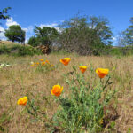
Wildflowers along the Catherine Creek Universal Access Trail in Lyle, Wash.
Wildflowers along the Catherine Creek Universal Access Trail in Lyle, Wash.
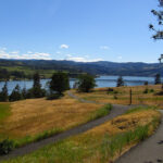
Having safely forded the river, we continued east on the Washington side through the city of Bingen toward Catherine Creek. The Catherine Creek Trailhead offers something for everyone, from a short 1.2 mile walk through the Universal Access Trail (UAT) to a long, hilly 8.2 mile out-and-back to Coyote Wall.
Before we left for our two-year journey in Japan, we’d hiked the West Loop trail and its spectacular views of the Gorge and nearby Rowland Lake. This time, we opted for the two-mile Arch Loop hike, but first, we walked the loop around the UAT. The paved interpretive trail is packed with great views of the Gorge and Mt. Hood. Dozens of varieties of wildflowers bloom at different times of the year, always offering a punch of color. Benches offer places to rest and enjoy the scenery and the entire trail is wheelchair-accessible.
An abandoned corral along the Catherine Creek Arch Loop trail.
After our warmup, we headed out the stone and gravel path toward the Arch Loop trail. The easy trail has a bit of incline as it winds through the light forest, across Catherine Creek and between tall stone cliffs. Opposite an abandoned corral is the trail’s namesake arch rock. The area is fenced off as it is a sacred area for the local Native American tribes.
View of Mt. Hood and the Columbia River from the top of the Catherine Creek Arch Loop trail.
We followed the trail up to the top of the arch rock where views of Mt. Hood and the Gorge fill the skyline. The flatlands at the top offer a great opportunity to explore or just sit and enjoy the views. Eventually, we left the vista behind, following the edge of the cliff until the trail picked up again. The last stretch was a bit underwhelming as we made our way down onto the highway for the final quarter-mile, but overall, Catherine Creek is an enjoyable stroll.
We crossed back to Oregon and headed into Hood River for a stop at one of our favorite breweries. Full Sail Brewing is the largest, yet still maintains a local feel at its brewery and taproom overlooking the Columbia River. Full Sail’s simple flagship beers are widely available, but it’s here in Hood River where the mastery of the craft really shines with a variety of seasonals and Brewmaster Reserve recipes always on tap.
After enjoying the seasonal sampler, we took a walk around the downtown area. Although quiet on the weekday evening, the charming and easily-walkable downtown is lively on the weekends with great local restaurants and shops. We finished up with one last pint and a pizza at Double Mountain Brewery before heading back toward Portland.
Sunset over the Columbia River.
Perhaps the only view more stunning than the eastern vista on a sunny day is the western view on a clear evening. The sun began to set as we approached the viewpoint near the historical marker commemorating the British explorers of the H.M.S. Chatham in the 1790s. The fiery sky reflected off the calm waters of the river, slowly gradating to the indigo of the evening. A perfect ending to a great day in the Columbia River Gorge.
Vista House at Crown Point
Follow the Historic Columbia River Highway east from the Portland Women’s Forum State Scenic Viewpoint.
Multnomah Falls
Follow the Historic Columbia River Highway east from Crown Point or take I-84 E to exit 31 (left-hand exit) for the Multnomah Falls parking lot.
Catherine Creek Trailhead
From I-84 E, take exit 64 near Hood River and turn left for Button Bridge Rd. Cross the toll bridge ($1 each way for most vehicles) and turn right on WA-14. Just before Rowland Lake, turn left onto Old Highway 8 to the trailhead parking.
Full Sail Brewing
506 Columbia St, Hood River. Open daily from 11 a.m.-9 p.m.